Great Saturday and Monday down South, Mid Coast from Wednesday afternoon
South Australian Forecast by Craig Brokensha (issued Friday 16th September)
Best Days: Saturday South Coast, Monday South Coast, Tuesday morning Surf Coast, Wednesday afternoon Mid Coast, both coasts Thursday
Recap
A rapid drop in stormy swell from Wednesday on the Mid was seen yesterday with 1ft+ surf along with torrents of water running out the Onkaparinga, reshaping the banks.
The South Coast was poor all day with onshore winds but plenty of size.
Today was the day to surf with clean good 3ft sets off Middleton and solid waves at Waits and Parsons under a light offshore wind. The Mid Coast was tiny and bumpy.
This weekend (Sep 17 - 18)
The weekend will be all about tomorrow. Offshore N/NW winds are due most of the day, swinging W'ly very late.
Small waves are due through the morning, coming in around 2ft or so at Middleton, bigger down towards Day St, and out at Waits and Parsons.
Into the afternoon a mix of new SW groundswells are due, building slowly and really kicking later in the day.
This swell was generated from Sunday evening through this week by a strong polar low firing up south-east of South Africa, traversing east to a position south-west of WA, and then weakening while approaching us.
A good kick to 3-4ft is due at Middleton late in the day, peaking Sunday to 3-5ft. The Mid Coast isn't expected to see any major size, building to 1-2ft later Saturday and persisting around this size Sunday.
Now Saturday's late change will be from a trough approaching from the west, with onshore S/SW winds due into Sunday, creating poor conditions across both coasts.
 Next week (Sep 19 onwards)
Into Monday a good couple of SW groundswells are due, and offshore N'ly winds are due all day across the South Coast.
These swells are being generated by a pre-frontal fetch of W/NW gales south-west of WA, followed closely by post-frontal W/SW gales. The first swell from the pre-frontal winds is due to arrive Monday morning, with the secondary swell for the afternoon.
Middleton should see good 3-4ft sets, with larger waves at Waits and Parsons, while the Mid isn't likely to top 1-1.5ft.
A drop in size is due into Tuesday morning down South with early W/NW tending SW winds.
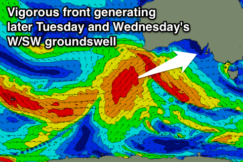
This change will be related to a vigorous but weakening mid-latitude front pushing in from the Bight. This front will initially form on the back of the storm generating Monday's swell, but project north-east towards WA and through the Bight while generating a fetch of W/SW gales.
A moderate to large W/SW groundswell is due off this front, building later in the day down South and peaking Wednesday.
The Mid Coast however should see an increase in W/SW windswell Tuesday to 2ft+ with onshore winds, peaking Wednesday to a strong 2-3ft.
The South Coast is expected to offer 3-5ft sets at Middleton, but winds will unfortunately be onshore from the SW, easing through the day. With this the Mid Coast should become fun into the afternoon as winds ease.
Thursday then looks great across both coasts with offshore NE winds and easing surf. We'll review this on Monday. Have a great weekend!

