Good surf down South with easing swells
South Australian Forecast by Craig Brokensha (issued Monday 5th September)
Best Days: South Coast Tuesday, Wednesday, Thursday morning, Saturday and Sunday morning, Mid Coast Tuesday morning, keen surfers Saturday
Recap
Good fun 2-3ft surf across Middleton on Saturday morning before a W/SW change hit, while the Mid was a bumpy 1-1.5ft.
A strong mix of new swells started to fill in on Sunday with clean fun 3ft sets off Middleton through the morning, stronger into the afternoon, while the Mid was a bumpy and choppy 1-2ft.
Today the peak in strong long-period SW groundswell was seen (generated by those severe-gale W/NW winds last week) with solid 4-5ft sets off Middleton under light offshore winds and clean 2ft sets on the Mid. A great day of surfing!
This week and weekend (Sep 6 - 11)
Today's strong pulse of SW groundswell will be slow in easing, with a reinforcing pulse of swell for this afternoon generated by a secondary fetch of W/NW gales moving in over the top of the original fetch.
Middleton should still offer 4ft sets tomorrow morning, with easing 1-2ft waves on the Mid, smaller into Wednesday from 3ft and 1ft respectively.
Conditions will be excellent again down South tomorrow morning with a N/NE tending SE breeze and then gusty N/NE winds Wednesday.
 The surf will continue to ease Thursday with Waits and Parsons the go, although winds will be gusty and from the N/NW, tending W/NW into the afternoon ahead of a strong mid-latitude front pushing through the Bight.
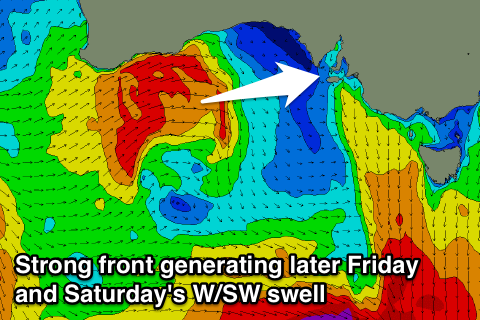
This front will begin its life in our far swell window today around the Heard Island region. A fetch of W/SW gales will project through our western swell window, weakening once pushing across the South West of WA Wednesday, only for a secondary slightly stronger system to race in and project a fetch of W/SW gales through the Bight.
We should see a moderate to large W/SW groundswell generated by this progression, building across the Mid Coast Friday and reaching 2-3ft into the afternoon, but similar amounts of W/SW windswell will also be in the mix.
The South Coast will be small early, building to 3-4ft later in the day at Middleton, peaking Saturday to a similar size, but with a greater period and more energy.
Winds on Friday won't be the best with a gusty W/NW tending W/SW breeze across all locations, while Saturday looks good as winds tend more NW through the morning, then back to W/NW into the afternoon.
Sunday looks clean most of the day with an onshore change due mid-late afternoon. This will be when a strong long-period SW groundswell starts to fill in, generated by a vigorous polar front firing up south-west of WA later this week.
This swell should be seen later Sunday and Monday morning but with poor E/SE-SE winds, and not much size for the Mid. More on this Wednesday.

