Good swell tomorrow, easing into the weekend, with an excellent clean swell Monday
South Australian Forecast by Craig Brokensha (issued Wednesday 31st August)
Best Days: Thursday South Coast, Friday morning South Coast, Sunday morning South Coast, Monday and Tuesday both coasts
Recap
Small clean waves across the South Coast yesterday morning ahead of an afternoon kick in good S/SW groundswell as winds remained offshore and eased. Middleton saw good 3ft sets, with more size out at Waits and Parsons.
Today the swell was slowly easing back from 2-3ft with W/NW breezes. The Mid Coast was tiny and bumpy yesterday, even worse today.
This week and weekend (Sep 1 - 4)
Remember: TODAY is your LAST CHANCE to win a trip for two to the Banyak Islands. More information here.
Tomorrow's new pulse of inconsistent SW groundswell is still on track, with good 3-4ft sets due off Middleton with the Mid coming in at an inconsistent 1ft.
Conditions should be good across both coasts with a variable wind, tending light offshore from the N/NE down South ahead of a really shallow S/SE change into the afternoon.
Come Friday similar conditions are expected with a variable tending light N/NE breeze and easing swell from 3ft at Middleton.
Saturday will be smaller again and clean in protected spots through the morning with a W/NW breeze ahead of a SW change through the early afternoon.
This change will be attached to a weakening front moving in from the west and will kick up a tiny increase in windswell on the Mid into the afternoon.
Sunday will be better with a new W/SW groundswell from the initial stages of this front. A pre-frontal fetch of severe-gale W/NW winds will be followed by a post-frontal strong to gale-force W/SW fetch projecting towards us, generating a moderate sized W/SW groundswell for Sunday.
The Mid Coast should build to 2ft through the afternoon, with the South Coast pulsing to 3-4ft during the morning. Light W/NW to W/SW winds are more than likely down South, while easing W'ly winds on the Mid should create OK conditions into the evening.
 Next week onwards (Sep 5 onwards)
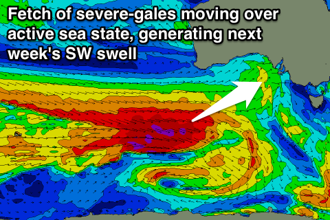
Of greater importance is the development of two separate and much stronger polar lows south-west of WA later this week and through the weekend.
An initial fetch of severe-gale W/NW gales will set in motion an active sea state for a more elongated fetch of severe-gale W/NW winds to move over, generating a large and powerful SW groundswell for Monday.
Middleton is expected to offer solid 4-6ft sets and conditions will be excellent under a N/NW tending variable wind. The Mid Coast should see good 2ft sets with NE tending variable winds. A slow drop in size is expected Tuesday as winds remain favourable.

