Fun days down South this week, plenty of swell from Sunday
South Australian Forecast by Craig Brokensha (issued Monday 29th August)
Best Days: South Coast tomorrow (afternoon), Wednesday morning, Thursday and Friday mornings South Coast
Recap
A slow start to the weekend Saturday with a small swell, best at Waits and Parsons for experienced surfers, while a fun new SW swell filled in yesterday with good 3ft sets off Middleton and solid sets out at Waits. The Mid Coast was tiny all weekend with clean conditions yesterday.
Today the surf was a bit smaller and conditions lumpy with a light NE'ly, which has since freshened. The Mid Coast has remained tiny.
This week (Aug 30 – Sep 2)
Tomorrow will start out small, but a new S/SW groundswell for the afternoon is due, but down a touch on Friday's forecast.
This will be due to the polar front generating it forming a little later than ideal within our southern swell window.
Middleton is only expected to be around 2ft early, increasing to a good 3ft through the afternoon, with the odd bigger one at Waits. Conditions will be great with a moderate to fresh but easing N/NE tending N/NW breeze.
A quick drop in size is then due Wednesday with W/NW tending W/SW breezes.
The Mid Coast will remain tiny tomorrow, but a weakening mid-latitude in the Bight will aim a weak fetch of W/SW winds through our swell window tomorrow, producing 1ft+ waves Wednesday.
Our inconsistent SW groundswell for Thursday is still on track, with a vigorous polar low firing up in the Heard Island region, generating a fetch of severe-gale to storm-force W/NW winds through our swell window.
This system is currently weakening along the polar shelf, with a secondary weaker fetch of NW gales moving in just behind.
This swell is expected to arrive late Wednesday and peak Thursday morning with good but inconsistent 3-4ft sets at Middleton and winds are due to be variable early before increasing from the S/SE through the day. The Mid isn't due to see any major size with inconsistent 1ft sets.
Friday is looking a little funky as a weak trough forms to our south-east, directing variable tending S/SW winds into the coast again as the swell slowly eases.
This weekend onwards (Sep 3 onwards)
 From the weekend we've got plenty of distant W/SW and closer more consistent SW groundswells on the cards.
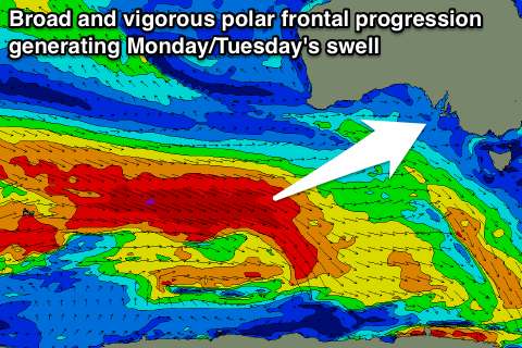
Saturday will be the low point, but not below 2-3ft at Middleton, while from Sunday some larger energy is due, from a vigorous polar frontal progression firing up in the southern Indian Ocean, moving under the country and closer to us through later this week and weekend.
Without getting into specifics just yet, a strong SW groundswell is first due Sunday with a secondary reinforcing pulse for the Monday and Tuesday. Winds may be an issue on the weekend but. Size wise these swells look to be around 3-5ft at Middleton and 1ft to occasionally 2ft on the Mid, but check back here Wednesday for more on this.


Comments
Nice lines at Victor this arvo.