Mix of W/SW and S/SW swells with east winds, better Friday and then Saturday
South Australian Forecast by Craig Brokensha (issued Monday 22nd August)
Best Days: South Coast Tuesday and Wednesday mornings, Mid Coast Wednesday, South Coast Friday and Saturday, magnets Sunday
Recap
Plenty of swell across the Mid Coast Saturday to 2-3ft but average sloppy conditions with moderate onshore wind. Sunday was smaller and back to 1-1.5ft and bumpy with a northerly wind.
The South Coast saw large clean surf in the 6ft range on the sets around town Saturday morning, while Sunday offered more options with a straighter offshore wind and easing SW swell from 3-4ft across Middleton.
Today the Mid was back to a tiny 1ft with the South Coast offering clean glassy lines of S/SW swell to 2-3ft at Middleton, better at Waits and Parsons.
This week (Aug 23 - 26)
The weakening 'bombing low' responsible for the weekend's large surf has been stalling south of Tassie, aiming a fetch of strong to gale-force S/SE winds towards us through our southern swell window.
This has generated a fun S/SE swell that's expected to arrive overnight hold through tomorrow then ease off Wednesday.
Most open beaches should come in around 3ft, possibly 3-4ft at Waits and Parsons, easing through Wednesday from the same size. Some new W/SW swell is also expected to be in the water tomorrow afternoon and Wednesday, generated by distant frontal activity in the south-east Indian Ocean.
This won't be above the size seen from the S'ly swell across the South Coast, but the Mid Coast should see a slight increase to 1-1.5ft later tomorrow, peaking Wednesday to 1-2ft.
A light E/NE wind (possibly variable) will create clean conditions across both coasts tomorrow morning, but it'll be a little peaky down South, with S/SE breezes into the afternoon.
Wednesday looks to play out similar, with fresher S/SE winds into the afternoon.
 Thursday looks like a lay day with easing surf across both coasts with SE tending S/SW winds.
Friday is looking better and improving through the morning with a new inconsistent SW groundswell along with light variable winds.
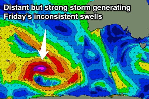
This swell has and it still being generated by a sustained and strong polar frontal progression moving through the southern Indian Ocean. This progression developed south of South Africa last week, and has been moving towards us, with it now being east of Heard Island, generating a weakening fetch of severe-gale W/SW tending W/NW winds.
A mix of inconsistent long-range W/SW groundswell energy along with some SW swell from the later stages of the progression are due, arriving overnight Thursday and peaking Friday morning to a good 3ft across Middleton and 1-1.5ft on the Mid Coast (but very inconsistent).
Early S'ly winds might be affecting quality on the South Coast early, but a variable tending light offshore is due from mid-morning, variable into the afternoon. This will create improving conditions.
Into the weekend easing surf with N'ly winds will favour swell magnets on the South Coast, while the Mid will be tiny.
Into next week inconsistent amounts of S/SW swell are due with offshore winds, but more on this Wednesday.

