Easing surf with strengthening onshores, large and stormy next week
South Australian Forecast by Craig Brokensha (issued Friday 8th July June)
Best Days: South Coast Saturday, stormy Mid Coast waves Monday and Tuesday, South Coast protected spots Tuesday morning for keen surfers, Thursday and Friday
Recap
Clean tiny 1ft waves across the Mid yesterday, pulsing a little into the afternoon before backing off again from 1ft this morning.
A strong new SW groundswell filled in across the South Coast, kicking to 3-5ft across Middleton and breaks around Victor with a light offshore tending variable breeze.
Today conditions were straighter and great with solid 3-4ft sets off Middleton under a light offshore wind. The swell should ease through the day as winds tend variable.
This weekend (Jul 7 - 10)
The South Coast will see easing surf over the weekend with clean conditions tomorrow, better towards eastern ends of beaches with a fresh N/NE tending NE breeze. Easing 2-3ft sets are due off Middleton and 3-4ft at Waits, fading from 1-1.5ft at Middleton and 2ft at Waits Sunday but under strong N/NE tending N/NW winds.
The Mid Coast will be tiny tomorrow but into Sunday we'll see building levels of NW windswell (although the size has been shifted more to Monday). Stormy 2-3ft waves are due by dark, tiny in the morning.
Next week onwards (Jul 11 onwards)
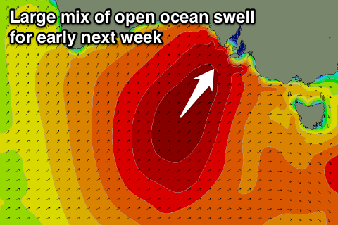
Into next week our large mix of stormy swells is still on track as we look at quite a dynamic and tricky multi-staged cold outbreak across the state.
 First over the weekend a broad and very intense mid-latitude low is forecast to develop, in the Bight with a fetch of severe-gale W/NW tending NW winds due to kick up a large stormy NW windswell across the Mid Coast for Monday.
Size wise we're probably looking at 3-5ft sets with gale-force but easing NW winds. This will result in the swell easing through the day as well.
The South Coast is due to bottom out Monday morning and be tiny, with only a small late increase in W/SW groundswell to 2-3ft at Middleton and 4ft+ around Waits and Parsons.
From Tuesday we'll see a broad and elongated fetch of gale to severe-gale S/SW winds shifting east and into our swell window, generating a large building SW groundswell through the day, peaking out of the S/SW Wednesday.
Early gusty W/NW winds will swing string W/SW through Tuesday as the swell builds, with Middleton due to reach 6ft+ by dark while the Mid Coast should see stormy 3-4ft+ waves all day.
At the peak of the swell Wednesday down South Middleton is expected to see easy 6-8ft sets with larger 10ft waves at offshore reefs, and out at Waits and Parsons. Conditions will be poor though with a fresh but easing SW'ly. There is a chance for an early W'ly but we'll review this Monday.
This Mid Coast will ease through Wednesday from the 3ft+ range, even smaller Thursday. Conditions will become much cleaner down South Thursday with a light N'ly offshore and easing 4-6ft sets at Middleton. We'll have one last look at this Monday and in the meantime, have a great weekend!


Comments
Great waves in the Bay this afternoon.