Poor start to the weekend, good Sunday and great next week
South Australian Forecast by Craig Brokensha (issued Friday 10th June)
Best Days: Sunday South Coast, Monday onwards South Coast
Recap
Average onshore 1-2ft waves across the Mid Coast yesterday with better conditions down South with a mix of groundswell and windswell to 3ft or so off Middleton.
Today poor conditions continued on the Mid Coast, while the South Coast was fun in protected spots with a W'ly wind and consistent 3ft of swell.
This weekend and next week (Jun 11- 17)
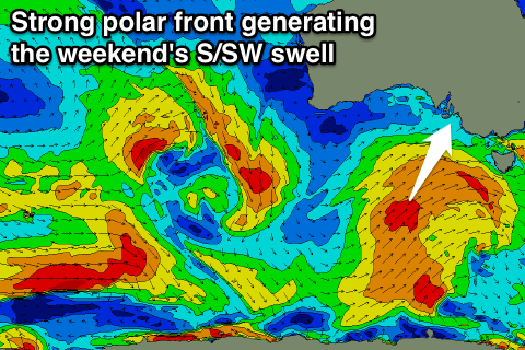
The weekend's swell has been upgraded a touch, with the frontal system generating it currently just to our south-west. A fetch of pre-frontal W/SW gales have formed earlier than forecast with this producing a good pulse of S/SW swell for tomorrow, followed by another pulse Sunday from trailing S/SW gales.
 This system will project north-east into Victoria, with the swell due to start building tomorrow afternoon mixed in with a longer-range SW groundswell.
Middleton is expected to be in the 2ft range early, kicking to a larger 4-5ft later in the day with bigger sets at Waits and Parsons. The Mid isn't due to see much size with tiny waves tomorrow, kicking to 1-1.5ft later and easing from a similar size Sunday morning.
Besides a possible early and short-lived W'ly wind tomorrow morning, gusty SW tending S'ly winds will create poor conditions across both coasts.
Sunday however is looking even better now with winds due to swing light offshore from the N/NE with easing 3-5ft sets at Middleton and 4-6ft waves at Waits and Parsons.
Monday will see the swell continue to ease with fresher N/NE winds. Middleton should still have 3ft sets, with 4ft+ waves at Waits and Parsons. The Mid will be tiny.
Into next week, our great run of waves is still shaping up.
We'll see a flurry of strong polar frontal activity from tomorrow through most of next week.
Stronger severe-gale W/NW to W/SW fetches should generate a moderate pulse of S/SW groundswell for Tuesday afternoon and Wednesday. This swell will build from a small base Tuesday and peak Wednesday around 3-5ft across the Middleton stretch with larger 6ft sets at Waits and Parsons. The Mid isn't due to really get above 1ft.
Additional pulses are due into Thursday afternoon and Friday from back to back polar lows, but we'll look at this in more detail Monday.
The great thing about next week though is persistent offshore N/NE winds as a slow moving high sits to our east. This will keep the South Coast clean most of the week, with a S/SE change on the cards Friday. We'll review this Monday, have a great weekend!

