Easing surf into the weekend with good swell and winds from Sunday
South Australian Forecast by Craig Brokensha (issued Wednesday 8th June)
Best Days: Early Thursday down South, Friday for keen surfers, Sunday onwards down South
Recap
Average onshore 1-2ft waves across the Mid Coast yesterday with an easing onshore wind, while the South Coast offered workable conditions in protected spots with a good 3ft of swell and W'ly breeze.
Today a strong new inconsistent SW groundswell has filled in with solid 3-5ft waves across Middleton and around town on the South Coast, while the Mid was a little underwhelming and only 1-1.5ft. This should kick through the day with the tide to 2ft, while the South Coast will become straighter under a strengthening offshore, but the afternoon may become too windy.
This week and weekend (Jun 7- 12)
Tomorrow morning will be all about the early surf down South with a dawn NW-W/NW wind expected to give into a strong onshore change mid-morning.
Today's SW groundswell should ease, but Middleton is expected to continue to offer 3ft+ sets, with larger 5ft waves at Waits and Parsons. The Mid will ease back from a bumpy 1-2ft.
Cleaner conditions will develop down South Friday with a moderate to fresh W/NW'ly, but the surf will be small, easing from 2ft at Middleton and 3-4ft at Waits and Parsons.
The weekend will start out slow and poor with small surf and poor conditions after an onshore S/SW change before dawn.
This change will be linked to a weak front moving in from the west, kicking up 1-1.5ft of W/SW windswell for the Mid during the day. The South Coast will see a new inconsistent SW groundswell filling in from a strong but short-lived polar low in our far swell window the last couple of days. This is expected to reach an inconsistent 3-4ft at Middleton and 5ft+ at Waits and Parsons but with poor conditions under that S'ly wind.
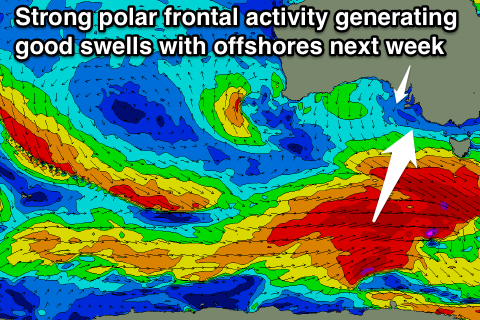
Of greater importance is a stronger polar low projecting a fetch of SW gales up towards Tasmania, through our southern swell window Friday and Saturday.
A good pulse of S/SW groundswell to 3-5ft at Middleton and 4-6ft at Waits and Parsons. The Mid won't see much size with easing 1ft+ sets. Conditions will improve considerably as a high pressure system moves in from the west, steering winds around to the NE and persisting all day.
Next week onwards (Jun 13 onwards)
 We've got a great week of waves due across the Surf Coast from Monday as a series of strong polar fronts fire up one after the other through our south-western swell window. The fronts won't be overly strong or project too far north but with the constant activity, moderate sized of SW groundswell are due.
Also a stationary high will direct persistent offshore N/NE winds across the South Coast all week, creating excellent conditions.
Size wise the best pulse is due later Tuesday/Wednesday at this stage, but more on this Friday.

