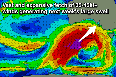
Slow few days ahead of a very large swell next week
South Australian Forecast by Craig Brokensha (issued Wednesday 27th April)
Best Days: Mid Coast tomorrow, exposed breaks South Coast tomorrow morning, Friday and Saturday and then Sunday onwards (plenty of swell for the Mid from later Saturday but onshore)
Recap
Small inconsistent but fun waves across exposed breaks yesterday down South, with the Mid coming in at a bumpy 0.5-1ft.
Today a better W/SW swell has offered 1-2ft waves across the Mid but with average winds, while the South Coast remained small due to the acute nature of the swell. A better increase is due this afternoon though to 2ft+ at Middleton and Cape du Couedic observations are lining up with this. Winds are due to swing more W/NW though later, favouring protected spots.
This week and weekend (Apr 28 – May 1)
South Coast: This afternoon's increase in small W/SW swell is due to be followed by a secondary small increase through tomorrow from weak fetches of W/SW winds in our immediate swell window.
Middleton should provide inconsistent 2ft+ waves most of the day, with larger 3ft to occasionally 4ft sets at Waits and Parsons before easing into Friday from 1-2ft and 2-3ft respectively.
Variable tending light offshore winds are due tomorrow ahead of sea breezes, with N/NW tending W/NW winds Friday.
Saturday will remain small with background levels of swell to 1-2ft across Middleton and 3ft+ sets at Waits and Parsons under N/NW tending variable winds.
From Sunday though our first and smallest in a series of W/SW groundswells is due across the coast.
Two pulses are actually due, one overnight Saturday and the other during the day Sunday, easing into Monday.
Theses swells will be produced by the first two storms to fall under a strengthening node of the Long Wave Trough moving into the Bight.
The first front will generate a fetch of strong to gale-force SW winds up and then under WA through the Bight ahead of a secondary stronger system following a similar path.
An initial W/SW groundswell arriving later Saturday peaking Sunday morning should see 3ft waves at Middleton and bigger 5ft surf at Waits and Parsons early before the stronger pulse fills in through the day, providing larger 4ft sets off Middleton and 5-6ft waves at Waits and Parsons.
Conditions are looking best in protected locations with a morning W/NW breeze, likely holding from the W all day if we're lucky. Easing clean surf is then due Monday with NW winds.
Mid Coast: Today's W/SW groundswell should ease into tomorrow but the reinforcing pulse for tomorrow is due to keep 1-2ft sets hitting the coast tomorrow with clean conditions all day. Friday should then see the swell ease back more to 1ft+ and persist around the same size Saturday morning.
The stronger W/SW groundswell pulses will provide much better size, with a late kick to 2-3ft likely before dark Saturday, holding 2-3ft most of Sunday before easing back to 2ft Monday. Winds will unfortunately be average and onshore for the most part.
Next week onwards (May 2 onwards)
Of much greater significance is the developments through early to mid-next week.
We're due to see one of the largest swell events for some while impacting the state as a result of the Long Wave Trough stalling over the Bight.
 This will direct back to back to back frontal systems up through our western and then south-western swell windows, with each system working on the sea state created by the one before it (amplifying wave growth).
The strongest of all the fronts will project an expansive and vast fetch of severe-gale to storm-force W/SW winds right up towards the state during the weekend and early next week, producing a large powerful and long-period SW groundswell.
The swell is due to build through Tuesday, peaking overnight and into Wednesday.
At this stage the model forecasts look about bang on with 8ft sets way off the back of Middleton, 10-12ft waves at Waits and Parsons and other offshore reefs while the Mid Coast is due to see 3-4ft+ of groundswell, with local windswell on top.
Conditions will be best in protected spots down South with a fresh and gusty W/NW wind Tuesday while Wednesday could see NW breezes if things go to plan.
We've still got plenty of time for the swell to change and evolve though, so check back here on Friday and Monday to see how the swells tracking.


Comments
And after Wednesday...?
Well after Wednesday winds look offshore ahead of a change Friday.
West Island Left ?
Tunks reef.
Sheepy you have a couple of bombies your way that will light up.
Southey why shouldn't I get excited this is a major event for a swell tracker
Yeah . The system is a beauty . The fact it stalls and the fronts dive SE is good . Was just trying to take a little if the froth off it .
Please help remove some froth
I hope this pans out..the cup may spilleth over!!
Best range of charts I've seen for a very long time :)