Fun windows of waves for both coasts
South Australian Forecast (issued Monday 14th March)
Best Days: Mid Coast Tuesday morning, South Coast Wednesday morning and Thursday morning, Mid Coast Saturday afternoon, South Coast Sunday morning
Recap
Small waves Saturday morning with a light onshore wind down South creating workable conditions for desperate surfers.
Sunday started off a little slow with lighter winds again ahead of a good inconsistent pulse of SW groundswell through the day as winds freshened from the S/SE. The Mid was tiny Saturday and Sunday morning, ahead of a fun kick in size during the mid-late afternoon.
Today the swell was back to a tiny 0.5-1ft on the Mid, with average onshore waves down South, but a reinforcing SW swell has started filling in, with better 1ft+ sets across the Mid. The South Coast is also picking up but a mess.
This week (Mar 15 - 18)
South Coast: This afternoon's increase in SW swell will be replaced by a better pulse tomorrow morning, generated by a good fetch of post-frontal W/SW gales in our south-western swell window over the weekend.
This will however be mixed in with a similar sized S/SE windswell from strong S/SE winds being aimed into us this afternoon/evening and early tomorrow morning.
Conditions will be poor though with a fresh and gusty SE breeze and 3ft+ slops across Middleton and 4-5ft waves at Waits and Parsons.
Wednesday looks much better as the surface trough linked to the onshore winds dips south-west over Victoria, swinging winds offshore from the N/NE along with a fun easing mix of swells from 2-3ft at Middleton and 4ft+ at Waits and Parsons.
Thursday morning will be clean again with a light N/NW offshore, tending W/NW ahead of a late weak change and best at exposed breaks with easing 2ft sets at Middleton, and 2-3ft waves at Waits and Parsons.
Make the most of these two days, as Friday will be generally tiny and poor as a stiff onshore S/SW change moves through.
Mid Coast: This afternoon's swell should reach 1-1.5ft across the Mid, with some good 1-2ft sets tomorrow morning with offshore winds, fading through Wednesday from 1ft+ or so.
The rest of the week should then see the swell continue to fade and become tiny.
This weekend (Mar 19 onwards)
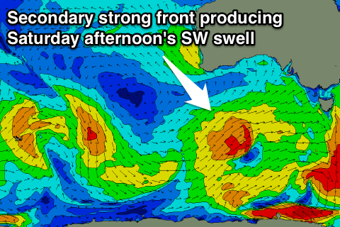
 South Coast: Two good pulses of SW groundswell are due through Saturday, generated by back to back frontal systems. Both will be pretty good in strength, the first developing south-west of WA and projecting a fetch of strong to gale-force SW winds towards us from tomorrow evening through until early Thursday.
A secondary strengthening system will push over the back on the initial front, producing good SW gales right on our doorstep while projecting closer towards us.
Two good moderate pulses of SW groundswell are due from these systems, both arriving Saturday. The first should peak through the morning, with the second into the afternoon.
Middleton is expected to build to a solid 3-4ft+ Saturday afternoon with 5-6ft sets at Waits and Parsons, easing back Sunday from a slightly smaller size.
Onshore S/SE winds look to create a few issues Saturday morning in the wake of Friday's change, but Sunday looks super fun as winds tend NE creating clean, but slightly peaky conditions.
Mid Coast: The second SW swell pulse for Saturday afternoon will be the best aligned and biggest with some good 2ft sets due, easing back from 1-2ft Sunday morning.
Longer term there's plenty more moderate sized SW groundswell pulses on the cards, but have a check back here Wednesday for more on this.

