Mid Coast Sunday afternoon onwards, poor South Coast until Wednesday/Thursday
South Australian Forecast (issued Friday 11th March)
Best Days: Mid Coast Sunday afternoon and Monday for tiny peelers, a touch better Tuesday, South Coast Wednesday and Thursday mornings
Recap
Favourable conditions have continued across the South Coast the last two mornings with variable winds and fun amounts of swell offering options from Middleton out to Waits. The Mid's hovered in the tiny 0.5ft range with morning offshores.
This weekend (Mar 12 - 13)
South Coast: The weekend isn't looking too flash, but if you're desperate to surf, Sunday will be the day.
Tomorrow we'll fall in between swells with poor and freshening onshore S/SE winds. There'll be no decent size or quality around at all.
Sunday's good but inconsistent increase in SW groundswell is still on track, with the frontal progression responsible currently dissolving south of WA.
This swell should fill in overnight and build through Sunday ahead of a peak into the afternoon to 3ft+ across Middleton and 5ft at Waits and Parsons. A moderate SE tending fresh S/SE breeze will leave no quality options though. There's a chance for an early E/SE'ly but still, conditions will be average.
Mid Coast: Tiny clean waves will persist tomorrow, but the new SW groundswell for Sunday should kick to a fun 1-2ft on the incoming tide and any afternoon sea breezes should kick back to the S/SE later.
Next week onwards (Mar 14 onwards)

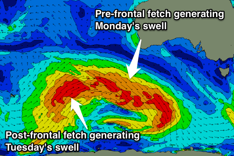
South Coast: A drop in SW groundswell is due into Monday morning, but a reinforcing and good SW pulse is due through the day, ahead of a secondary slightly bigger pulse Tuesday.
These swells will be generated by the one frontal system, with an initial pre-frontal fetch of gale to severe-gale W/NW winds followed by a better aligned post-frontal W/SW fetch.
Size wise, Middleton should hold around 3ft Monday with 4-5ft sets at Waits and Parsons, with a slightly better kick Tuesday morning to 3-4ft and 5ft+ respectively.
This will unfortunately coincide with strong S/SE winds developing across the coast as a strong high pressure system sitting to our south-west is squeezed by a deepening inland surface trough over Victoria.
Junky levels of S/SE windswell will also develop into Monday afternoon, persisting Tuesday before fading Wednesday as moderate levels of SW groundswell persist.
Conditions won't improve until Wednesday morning, but more so Thursday when winds swing offshore from the N/NE. This looks like the best day to surf with easing SW swell from 2ft+ at Middleton and 3ft+ at Waits and Parsons.
Longer term some new fun SW groundswell is due into next weekend, but more on this Monday.
Mid Coast: Sunday's swell should back off from 1-1.5ft Monday morning, with the reinforcing SW groundswell pulses due to maintain 1-1.5ft sets into the afternoon, peaking Tuesday to 1-2ft. The size should then fade through the rest of the week. We'll look at this again Monday and in the meantime, have a great weekend!


Comments
Never get the se component of your swells....i know we can get swell from there but at what meters does it add or subtract from the underlying pulse?