Poor wind outlook continues
South Australian Forecast (issued Monday 8th February)
Best Days: Saturday morning down South, beginners on the Mid later tomorrow and Wednesday
Recap
Small clean waves Saturday morning across the South Coast with variable winds, best out at Waits and Parsons.
Sunday was a touch smaller but poor with onshore winds. The Mid Coast was tiny to flat all weekend.
Today fresh onshore winds continued to create poor conditions down South, with tiny 0.5-1ft peelers on the Mid.
This week and weekend (Feb 9 - 14)
South Coast: Our poor wind outlook for the week ahead is still on track, with tomorrow probably being the cleanest with lighter E/SE breezes developing through the morning. There'll be no significant swell though with a weak and small S/SE windswell ahead of a new SW groundswell through the afternoon.
This groundswell and a better pulse for Wednesday have been generated by a relatively weak polar frontal progression that's now just south-west of Tassie and moving east under it.
Middleton should offer fun 2-3ft sets 4ft waves at Waits and Parsons when it peaks Wednesday morning but with fresh S/SE winds. A drop in swell is due into Thursday as S/SE winds continue, with another new SW swell expected to build Friday afternoon, easing Saturday.
Another relatively weak but more distant frontal progression will generate this swell to the south-west of WA, resulting in a bit less size and consistency compared to Wednesday's
Fresh SE tending S/SE winds will persist Friday, but as the swell eases Saturday we should see a reprieve in the SE winds, with a morning W/NW'ly due. Middleton should be clean with easing 2ft+ sets and 3-4ft waves at Waits and Parsons.
The window of better conditions will not last long, with fresh onshore S'ly winds due to kick back in again from Sunday and persist all of next week as a new large blocking high moves in from the west.
Mid Coast: Tiny waves are due tomorrow, with the SW kick later tomorrow and more so Wednesday likely to provide inconsistent 1ft sets before easing through Thursday. The secondary SW swell pulse for Friday afternoon and Saturday morning will be a touch smaller with tiny 0.5-1ft waves due across the Mid.
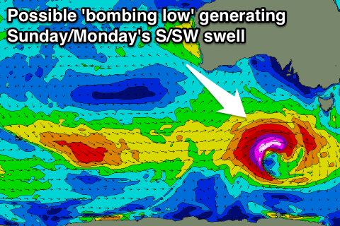
 Longer term, a weak front moving in under the country during the end of the week is expected to form into a 'bombing low' south-west of Tassie, dropping over 24hPa in less than 24 hours.
As the low 'bombs' a fetch of severe-gale to storm-force SW winds are due to be created in the South Coast's southern swell window, producing a moderate sized S/SW groundswell for later Sunday and Monday. Winds are poor though as outlined above. More on this Wednesday.


Comments
Lovely small lines on the Mid Coast this arvo.
When the southport cam pans sth ....there a perfect piece of advertising space on that gutter.
Ha! We'll realign the cam soon. Almost time for an upgrade.