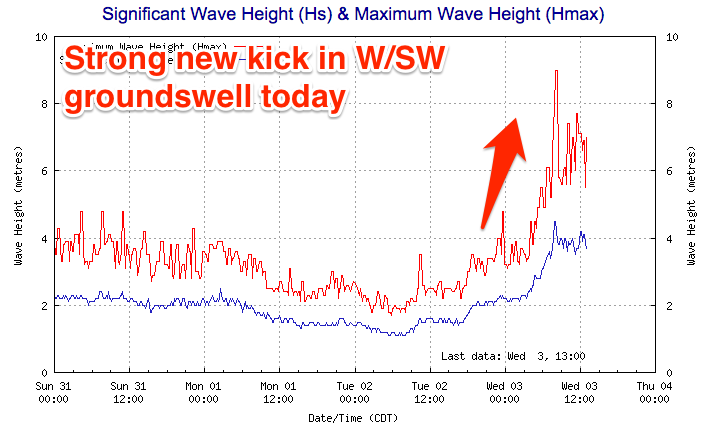
Good Mid Coast tomorrow, workable South Coast Saturday morning
South Australian Forecast (issued Wednesday 3rd February)
Best Days: Mid Coast tomorrow and Friday, South Coast Saturday morning
Recap
Small to tiny surf only doable at Waits and Parsons yesterday with morning NE winds. The Mid was clean but effectively flat.
Today a strong new W/SW groundswell has started to push in, with the Cape du Couedic wave buoy jumping to Maximum Wave Heights of around 4m with Peak Periods of 15s.
This has seen the Mid Coast kick from a windswelly and weak 1-2ft this morning to a stronger 2ft+ this afternoon, with 2ft to occasionally 3ft sets due into this evening as winds continue to improve and tend S/SE.
The South Coast was small and onshore this morning but we should see late sets pushing 3-4ft across the Middleton stretch although a total mess.
This week and weekend (Feb 4 - 7)
 South Coast: Today's strong kick in W/SW groundswell was generated by a vigorous mid-latitude low that fired up under WA, with the low since weakening while pushing east through the Bight.
The low has dipped south-east under us, with a trailing fetch of SW gales now being generated through the South Coast's southern swell window.
What we should see is an easing SW tomorrow from the 3-4ft range across the Middleton stretch and 5ft+ at Waits and Parsons, smaller into Friday morning ahead of a new pulse of S/SW groundswell through the day to 3ft and 4ft+ respectively across Middleton and Waits.
The forecast graph is wigging out a bit and combining windswell with the groundswell pulses, so ignore those massive spiked midday tomorrow and later Friday.
Conditions will be poor unfortunately with strengthening S/SE winds tomorrow and SE tending S/SE winds Friday.
Saturday morning is the best as the S/SW swell eases from 2-3ft at Middleton and 3-4ft at Waits under improving conditions as early light SE winds tend variable and likely around to the N/NE before a fresh S/SW change moves in. Therefore mid-late morning will probably offer the cleanest and best conditions.
Saturday's onshore change will linger into Sunday with no new significant swell, creating poor conditions.
Mid Coast: This afternoon's strong kick in W/SW groundswell is expected to peak this evening, but tomorrow should still offer 2ft+ waves through the morning, backing off through the afternoon with leftover 1ft to occasionally 2ft sets on Friday.
Conditions should be OK tomorrow with fresh S/SE-SE winds, cleaner Friday with a SE offshore ahead of S/SW sea breezes, and kicking back to the S/SE late.
Into the weekend fading tiny 0.5-1ft sets are due Saturday, tiny Sunday with clean conditions each morning.
Next week onwards (Feb 8 onwards)
South Coast: As touched on in Monday's update, a stationary high will dominate our region next week, with persistent onshore S/SE winds and a mix of weak S/SE windswell and SW groundswell for most of the week. There'll be nowhere to surf, while the Mid Coast will remain tiny and not offer any decent size.
This pattern looks to persist for at least the next week and a half, but more on this Friday.


Comments
Head high sets on the Mid (middle left first image)..