Strong W/SW groundswell mid-week
South Australian Forecast (issued Monday 1st February)
Best Days: Exposed breaks down South Tuesday morning, Mid Coast Wednesday afternoon, Thursday and Friday
Recap
Terrible conditions Saturday with a fresh onshore wind and stormy average conditions, best on the Mid with tiny 1-1.5ft peelers.
Sunday was much better down South with a light wind from the W and good 2-3ft sets at Middleton, with more size out at Waits and Parsons. The Mid continued to offer tiny fun 1-1.5ft sets on the right equipment.
This morning variable winds down South and a small background swell to an inconsistent 2ft at Middleton offered OK conditions for keen surfers. The Mid was clean but tiny.
This week (Feb 2 - 5)
South Coast: Swell magnets will be the only surfable spot down South tomorrow, with a fading swell from today and NE wind. Waits and Parsons should offer easing 2ft+ sets for keen surfers.
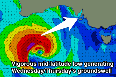
An onshore change on Wednesday will be linked to a vigorous but weakening mid-latitude low moving in from the west.
This low which is developing south of WA today, will aim a fetch of severe-gale to storm-force W/SW winds through our western swell window, before weakening while dipping south-east, moving more into our south-western swell window.
A moderate to large W/SW groundswell should be generated, kicking very strongly Wednesday afternoon on the Mid, with the South Coast seeing Middleton kicking late to 3ft with 4ft sets off Day St, and larger 5ft+ waves at Waits and Parsons.
 Thursday morning should reveal similar sized sets, while a trailing fetch of SW gales on the back of the low should generate a reinforcing S/SW groundswell for Friday, keeping 2-3ft waves hitting Middleton with 3-4ft sets at Waits and Parsons.
Unfortunately conditions will become poor Wednesday with fresh and gusty SW tending S'ly winds, persisting from the S/SE Thursday and SE Friday. With these winds there'll be some junky S/SE windswell in the mix Friday, but the models are over forecasting the size into the evening as it combines the S/SW and S/SE swells incorrectly.
Mid Coast: Tomorrow should remain tiny, but Wednesday afternoon's strong kick in W/SW groundswell should reach 2ft to nearly 3ft later in the day on the small incoming tide, peaking overnight and easing from a similar size Thursday morning.
Friday should then see inconsistent 1-2ft sets most of the day.
Conditions Wednesday will improve with fresh to strong S/SW winds expected to swing S/SE late in the day, with SE offshores Thursday and Friday mornings.
This weekend onwards (Feb 6 onwards)
South Coast: Unfortunately a stationary and strong high pressure ridge is due to move in across the Bight during the weekend, staying put through the first half of next week at least.
This will create poor S/SE winds across the South Coast, while also deflecting any major swell generating systems away from us, meaning the Mid won't offer any decent waves either.
Therefore make the most of the coming week of waves.


Comments
There is no mention of Wednesdays west swell in the ordinary forecast, only the forecasters notes. Seems odd???
Yeah, the Mid Coast forecast undercalls consistently and we've got a tweak ready to go, to fix this. Hopefully put through soon. So best bet is too read the Forecaster Notes in the meantime.
Nah don't fix it, :0 :) :)
Due sth swell for w.a. 4m will be a different angle than for vic just saying. I will be observing the sth angle on the directional buoy at alb
Good kick in swell on the CDC buoy..
Yeah looks like a surge of swell was whipped up nice from that cell craig even alb had 5 @12 & esp 3@12 or 13 sec maybe
Yeah, aimed right into Albany!
You'll be on for the late arvo session.
Yeah right now