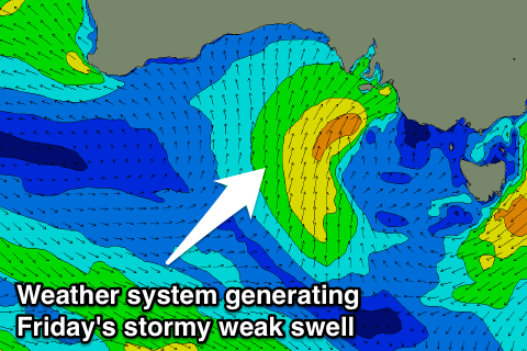
Poor end to the week, not improving until Monday
South Australian Forecast (issued Wednesday 27th December)
Best Days: Sunday morning keen surfers down South, Monday morning down South
Recap
Sloppy poor 2-3ft sets yesterday morning across the South Coast with fresh SE winds, while the Mid Coast was clean but tiny to 0.5ft.
Today cleaner conditions were seen down South with variable winds and 2-3ft of swell across exposed locations.
This week and weekend (Jan 28 - 31)
South Coast: Tiny weak surf is due across the South Coast tomorrow and besides a possible early W/NW breeze, conditions will be average as a fresh SW change moves through.
 This change will be linked to a relatively weak front pushing up and into us from the south-west, projecting a fetch of strong S/SW winds into us during tomorrow, followed by a secondary more S'ly fetch Friday afternoon and evening.
This will result in two pulses of short-range and weak swell, the first for Friday morning to a stormy 3-4ft or so across most locations (easing through the day), along with fresh to strong S/SW tending SW winds.
A secondary pulse is then due Saturday, with a touch more size to 4ft+ or so along with poor S/SW winds. The swell should drop away through Sunday with lighter onshore S/SW winds, creating workable conditions for keen surfers.
Mid Coast: A junky increase in windswell is due later tomorrow to 1-2ft by dark, with similar sets through Friday, if not more in the 1-1.5ft range, fading from 1ft Saturday as poor winds continue.
Next week onwards (Feb 1 onwards)
South Coast: Winds should swing offshore on Monday across the South Coast, and a new inconsistent SW groundswell due through Sunday from a strong but distant polar low, should ease. The morning should offer inconsistent 2ft+ sets at Middleton with 3ft+ waves at Waits and Parsons with N/NE offshores ahead of afternoon sea breezes.
Tiny leftovers are on the cards for Tuesday while into the middle to end of the week, a moderate to large sized SW groundswell is expected across the state as a deep mid-latitude low forms in the Bight.
Winds associated with this swell look to be onshore from the SW at this stage, but check back here Friday for more info.

