Poor week ahead
South Australian Forecast (issued Friday 22nd December)
Best Days: No good days
Recap
A good kick in new SW groundswell offered solid waves across the South Coast yesterday while light variable winds did their best to create clean conditions before sea breezes kicked in. The Mid offered tiny clean waves for beginners, while further afield pumped.
Today the swell was easing with light variable winds again, best down South at exposed breaks.
This weekend and next week (Jan 23 - 29)
South Coast: I hope you've made the most of the last couple of days waves, as the outlook from tomorrow is poor, with no significant swells and relentless onshore S/SE winds.
Today's reinforcing S/SW groundswell down South should ease back through tomorrow, from 2-3ft at Middleton and 4ft at Waits and Parsons but a gusty S'ly change this evening will persist into tomorrow with fresh and gusty S'ly winds.
Sunday will be small and slightly better with weaker but still moderate S/SE onshore winds.
Through next week a slow moving high pressure ridge sliding in from the west will keep persistent SE to S/SE winds blowing down South through until about Thursday, when an approaching mid-latitude low disrupts the flow. In this time no significant swell is due either, so go get those dings fixed!
Unfortunately there isn't due to be any decent swell in the water with morning offshore NW winds but tiny 0.5-1ft waves at Middleton and 1ft+ sets at Waits and Parsons.
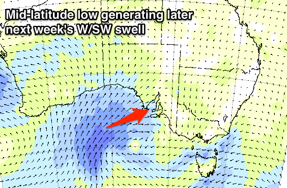
 Current forecasts are divergent on the evolution of this mid-latitude low, but latest updates have it stalling in the Bight, generating sustained strong to gale-force W/SW winds, producing a good sized W/SW swell for the Mid Coast later Thursday and more so Friday, while the South Coast will struggle to see any real size. Have a check back here Monday for an update on this though.
Mid Coast: Inconsistent and tiny 0.5-1ft surf is due to pad out the weekend, while later Monday and Tuesday morning a slight pulse of mid-period SW swell should keep the coast from going flat.
Of greater significance is the W/SW swell due to build through later Thursday, with sets to 1-2ft due later in the day with onshore W/SW winds, peaking Friday in the 2ft to possibly 3ft range as winds swing more S/SW. We'll have a closer look at this on Monday. Have a great weekend!

