Improving weekend, best Sunday morning
South Australian Forecast (issued Wednesday 30th December)
Best Days: Saturday morning and Sunday morning South Coast, every morning next week exposed breaks down South
Recap
Lighter winds and peaky fun 2-3ft waves across the South Coast yesterday morning, with tiny peaky waves on the Mid to 0.5ft.
Today onshore winds are back in from dawn, creating poor conditions around Victor, while the Mid remained tiny to flat.
This week and weekend (Jan 7 - 10)
South Coast: There's been no real change to the coming days forecast with poor onshore winds and junky levels of S/SE windswell in the 3ft range due to continue tomorrow, easing back a touch Friday mixed in with an inconsistent SW groundswell.
Fresh SE winds will swing more S/SE tomorrow, tending a little more favourable from the E/SE Friday morning before kicking back around to the S/SE through the afternoon.
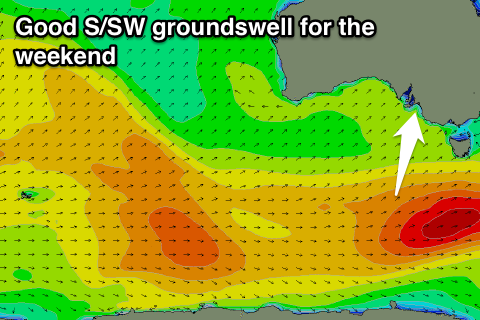
 The weekend is looking better with a good pulse of S/SW groundswell and improving winds.
The size of the S/SW groundswell has been upgraded a little, with the polar frontal progression generating it due to be a touch stronger than forecast on Monday.
A pre-frontal and then post-frontal fetch of W/NW and W/SW gales should produce a good kick in S/SW groundswell Saturday, building to 3ft at Middleton and 4ft+ at Waits and Parsons through the day before easing back from 2-3ft and 4ft respectively Sunday morning.
Conditions will improve Saturday morning but remain less than ideal with an E'ly breeze (possible E/NE at times) before sea breezes kick in.
Sunday is the pick though as winds tend more N/NE through the morning ahead of afternoon sea breezes.
Mid Coast: An inconsistent long-range SW groundswell should provide 1ft sets on the favourable parts of the tide tomorrow, before fading from 1ft or so Friday morning.
The weekend won't provide any love, with the swell too south to get into the Mid Coast.
Next week onwards (Jan 11 onwards)
South Coast: A new pulse of very inconsistent SW groundswell is due Monday but from a vigorous polar low in the southern Indian Ocean. It looks like our models are over-forecasting this swell, combining background energy with this new long-period swell.
Instead we're only likely to see inconsistent 2ft+ sets at Middleton with 3-4ft waves at Waits and Parsons. Variable winds are due through the morning ahead of afternoon sea breezes with smaller leftovers Tuesday with favourable winds again through the morning.
Unfortunately there's no significant swells due next week, but conditions look favourable each morning at this stage.
Mid Coast: The odd 0.5-1ft set may be seen through Monday with the inconsistent SW groundswell, while the rest of the week is due to be tiny, with a better W/SW groundswell on the cards for later in the week to 1-2ft or so from an intense but distant mid-latitude low. More on this Friday.


Comments
C'mon winter!