Great Thursday, poor until sometime next week
South Australian Forecast (issued Wednesday 30th December)
Best Days: Thursday both coasts, Friday small peelers Mid Coast
Recap
A continuation of peaky 2-3ft waves across the South Coast yesterday with early light E'ly winds, while the Mid saw tiny 0.5-1ft sets, biggest through the afternoon.
Today a strong new W/SW groundswell has filled in across both coasts with offshore winds, coming in at 3-4ft across Middleton and even larger out at Waits and Parsons. The Mid Coast was only around 1ft early but has since pulsed with bigger sets across all breaks.
This week and weekend (Dec 31 – Jan 3)
South Coast: Tomorrow morning will be the best day to surf down South over the coming period, as poor winds are due from Friday well into next week.
Today's good pulse of W/SW groundswell should ease through tomorrow from 3ft at Middleton and 4ft+ at Waits and Parsons under straight offshore N'ly winds ahead of mid-afternoon sea breezes.
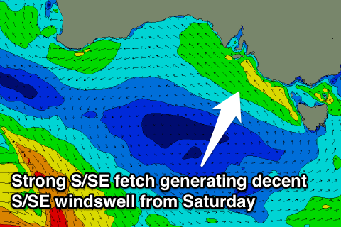
 A surface trough will then move in through Friday morning, bringing with it strengthening S/SE winds and building levels of S/SE windswell later in the day, peaking through Saturday to a solid but junky 4-5ft across most locations.
The trough will stall over eastern Victoria for the entire weekend and early next week resulting in persistent S/SE winds and moderate amounts of S/SE windswell persisting through Sunday and Monday before fading Tuesday as winds hopefully tend more E/NE across the region. We'll have to confirm this on Friday.
Mid Coast: Today's pulse in W/SW groundswell should be backed up by reinforcing pulses through tomorrow and Friday in the 1-1.5ft range before fading through Saturday from 1ft or so. Clean conditions are due for the most part, bumpiest through Friday with those S/SE breezes.
Longer term there's nothing too significant on the cards with the surface trough stalling over Victoria and stationary high pressure system directly south-west of us, setting up a large blocking pattern. Therefore make the most of tomorrow's waves down South!


Comments
How's the corduroy at Middleton!
Ben what about the swell spike this morn on cdc where did that come from ? It didn't seem to be forecast
Yeah interesting, there were a couple of reinforcing W/SW swell pulses due on the back of the initial pulse Wednesday.
Wednesday's swell was generated by 35-50kt pre-frontal W/NW winds, but the post-frontal W/SW winds have produced today's secondary pulse.
Yes rogar dat craig good then
Either of you guys notice the swell peak at Pt NPN before the period on Wednesday .
Also some spots in Vic were even bigger than Cape Sorrel .
Ah no, got the data?
Bigger than the sorrell buoy ? Alb , Cdc & sorrell had peaks about the same 4m . Very unlikely that vic could have anything more than 4m considering the storm track .please try to explain southey
No it's gone from the Port data which only lasts 48 hrs .
Basicly the swell period dropped from 14-15 which it was running with at small sizes the days prior . Then it got down to 11-12 ( roughly ) as the swell halfway on the increase .
As soon as the new swell ( 17 sec interval arrived ) the swell started rapidly dropping in size . ( it showed the swell peak at 12 noon on Wed. ) and correlates with a swell peak earlier west of there .
There was some real " west " bombs on Wednesday morning , and camel if you draw a line WSW of there I reckon you may find it in the " peak " swell energy alignment window
for these types of pre frontal swell events .
Ok , southey thats different from the other buoy readings . They all followed the same pattern that was easy to follow . heard that it was 8-12 ft in W V which is about what the buoys say ( except for your buoy) .
Southey the cdc buoy did have a bit more period than sorrel & maybe vic got more like it than tas swell ??
Last Wednesday was as good as it gets around my way. The local was 4 to 6ft and a screaming northerly offshore was opening up the barrels with 40 degree heat. The only place to be was in the water. This iPhone pic doesn't really do it justice......