Small period ahead, best suited to swell magnets
South Australian Forecast (issued Friday 4th December)
Best Days: Mid-morning onwards down South Saturday, Sunday morning down South, Wednesday morning both coasts
Recap
Good clean easing 2ft surf across the Mid Coast yesterday, with the South Coast also improving with better winds and good 3-4ft sets off Middleton, with more size out at Waits and Parsons.
Today the swell was smaller to 1-1.5ft on the Mid and 2-3ft at Middleton under favourable winds again, but sea breezes are now just starting to kick in.
This weekend and next week (Dec 5 - 11)
South Coast: Swell magnets will be the pick tomorrow morning as we fall in between pulses, with inconsistent 1-2ft waves due at Middleton and 2-3ft sets at Waits early, ahead of a new inconsistent SW groundswell building through the morning. This swell should reach 2ft to possibly 3ft across the Middleton stretch, with 3-4ft sets at Waits and Parsons but morning NE tending N/NE winds will give into fresh S/SE sea breezes from early-mid afternoon.
The swell will ease through Sunday from a small 2ft along the Middleton stretch with 3ft sets at Waits under similar winds, although sea breeze are due to kick in earlier.
Monday morning should become clean again down South but the surf will be tiny with Waits and Parsons the only real option for a surf with 2ft sets.
Give Tuesday a miss as even tinier waves are due under NW tending W/NW winds. A late kick in new small swell is due but it's not worth the drive from Adelaide.
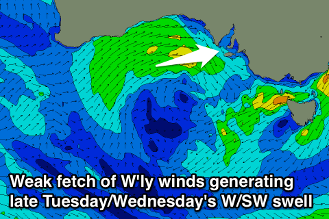
Into Wednesday a mix of inconsistent long-range SW groundswell from the Indian Ocean, and small weak W/SW windswell from a weak low pushing across us is due.
It looks like the models are overcooking the size a little, and I'm only expecting an inconsistent building 2ft wave at Middleton and 3ft+ sets at Waits and Parsons. Morning W/NW winds will favour protected spots before shifting onshore.
Thursday should be cleaner at more exposed breaks with a N'ly offshore and easing swell.
 Mid Coast: Tiny waves are due over the weekend, with tomorrow afternoon likely to provide the most size with sets to 1ft, fading Sunday.
The W/SW swell due off the weak low forming next week has been downgraded with a later formation of weak W/SW winds now due through Monday evening, pushing east towards us Tuesday.
This will result in a late kick in W'ly swell to 1-2ft on dark, easing from the 2ft range Wednesday morning with light onshore winds.
Longer term some better sized W/SW groundswell is due into next weekend from a slow moving and persistent low, but more on this Monday. Have a great weekend!

