Average weekend with lots of swell for next week
South Australian Forecast (issued Friday 20th November)
Best Days: Mid Coast Saturday, South Coast possibly early Monday, South Coast Tuesday and Wednesday
Recap
Nothing to really surf with tiny offerings down South and on the Mid Coast the last few days.
Today was the same but with developing onshore winds across the South Coast, and lighter winds on the Mid. A good kick in new W'ly swell is being seen across the Mid now though, with the Cape du Couedic buoy jumping through this morning. Light winds are creating workable conditions, but these will continue to increase into the afternoon.
This week and next week (Nov 21 - 27)
South Coast: Nothing too special on the cards tomorrow, even with a lift in swell. Onshore S'ly winds will create poor conditions with a W/SW swell easing from 2ft at Middleton and 3ft+ at Waits and Parsons.
Lighter and possibly variable S'ly winds are likely Sunday morning with a small S/SW swell to 2-3ft across most breaks, not worth the drive from Adelaide.
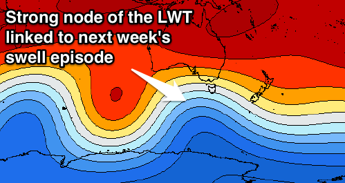
Late in the day though, the first pulse of strong S/SW groundswell in an extended run of surf through next week is due, with two successive and different phases of the Long Wave Trough due to influence our swell window.
The first is currently steering a vigorous polar frontal progression from the south-east Indian Ocean up towards Tasmania, generating multiple fetches of W/SW gales.
 We should see a moderate to large S/SW groundswell result from this first incarnation, building very strongly later and reaching 4-5ft at Middleton, with 6ft+ sets at more exposed breaks.
The swell should hold well Monday morning ahead of a slight drop through the day, halted a reinforcing SW groundswell filling in from a secondary weaker front moving through our swell window. This should keep Middleton around 3-5ft with 5-6ft sets at waits into the afternoon, easing further Tuesday morning.
Now the second phase of the Long Wave Trough will be more pronounced across Victoria, directing front after front straight up towards us and Victoria from Sunday through most of next week, while slowly pushing east.
This will produce large levels of consistent S/SW swell from Wednesday through Friday across the South Coast, easing later in the day and further into next weekend.
Size wise we'll probably see Middleton peaking around 4-6ft with larger sets at Waits and Parsons and winds should be favourable and offshore from the W/NW-NW (besides Monday and Thursday).
Mid Coast: Today's building W'ly swell is expected to ease back to 1-2ft tomorrow, with morning S/SE winds creating decent conditions.
Tiny surf is then due Sunday with the new S/SW groundswell unlikely to pulse over 1ft later in the day and Monday.
The secondary S/SW swell energy looks to be a bit better and to 1-1.5ft Wednesday and Thursday before fading Friday. Have a check back here on Monday for confirmation on this though. Have a great weekend!


Comments
Still a few nice small lines pushing through the Mid this morning.
Some solid readings on the Cape Decoudic buoy past few days.
Very, pity about the wind!