Fun improving weekend, good strong swell filling in Monday
South Australian Forecast (issued Friday 6th November)
Best Days: Saturday morning, Sunday, Monday, Mid Coast Tuesday afternoon and Wednesday morning for small waves
Recap
Early W'ly winds but small leftover waves across the South Coast yesterday morning before a strong onshore change moved through late morning. Today a new mix of SW groundswells filling in across the coast have been spoilt by onshore S/SW winds down South, with a weak 1-1.5ft of windswell also in the mix on the Mid.
This weekend (Nov 7 - 8)
South Coast: Improving conditions are due tomorrow down South with some solid swell still around through the morning to an easy 3ft+ at Middleton and 4-5ft at Waits and Parsons. Light NE winds should develop through the morning, cleaning up the surf before lunch ahead of SE sea breezes.
Sunday looks the cleanest with straighter offshore N/NE winds, tending more variable into the afternoon. Size wise, the Middleton stretch should be easing from 2ft to possibly 3ft, with better 3-4ft+ sets at Waits and Parsons.
Mid Coast: Today's kick in windswell and groundswell is due to ease back through tomorrow from 1ft or so, with those offshore winds. Sunday is then due to be tiny.
Monday onwards (Nov 9 onwards)
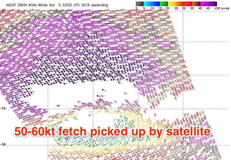
 South Coast: Monday afternoon's strong kick in long-period and inconsistent SW groundswell is still on track, with a 'bombing low' south-west of WA generating a storm-force W'ly fetch in our far swell window. Satellite observations confirm this fetch with 50-60kt barbs recorded, but not quite to the hurricane-force strength.
The low will track east-southeast while slowly weakening today, leaving a strong, inconsistent SW groundswell to spread up towards us for Monday. The long-period forerunners around 21-22s are due to hit Cape du Couedic Sunday evening, with the bulk of the swell filling in around the 16-17s range Monday midday/afternoon across our region.
The Middleton stretch should build to an inconsistent but good 3-5ft, with 6ft surf at Waits and Parsons through the day, smaller early. Conditions are looking good for most of the day as well with morning offshore N'ly winds due to tend variable ahead of a late S'ly change which hopefully stalls a little.
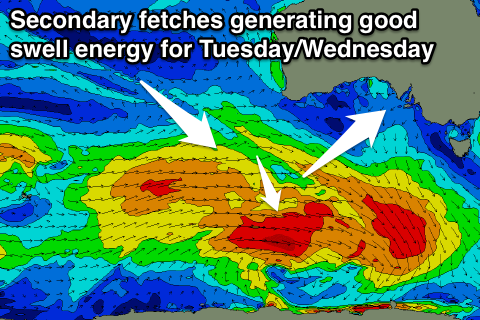
Into Tuesday and Wednesday reinforcing pulses of similar sized SW groundswell are due across our state, produced by a broad, slow moving and elongated fetch of trailing W/SW winds in the wake of the 'bombing low'.

The strongest pulse Tuesday afternoon should kick Middleton back to 3-5ft with 6ft sets at Waits and Parsons, easing from 3-4ft and 5-6ft respectively Wednesday morning, further down Thursday.
Unfortunately winds Tuesday will be poor as a stronger S/SE'ly develops, possibly tending more E/NE Wednesday morning but likely onshore again Thursday. More on this monday.
Mid Coast: Monday's inconsistent SW groundswell should kick to an inconsistent 1ft+ across the Mid through the day, with the secondary SW swells looking better, pulsing to 1-2ft Tuesday afternoon and easing from 1-1.5ft Wednesday morning with those favourable winds. Have a great weekend!


Comments
Stunning morning at Victor!
Real nice!