OK weekend, not too flash next week
South Australian Forecast (issued Friday 30th October)
Best Days: Saturday morning small waves, Sunday semi-protected spots, possibly Wednesday morning
Recap
Fun new S/SW groundswell yesterday with variable winds through the morning offering workable waves across most spots down South, while today similar conditions were again see with good 2-3ft waves across the Middleton stretch and more size out at Waits. Onshores have again kicked in deteriorating conditions for the afternoon surf. The Mid saw tiny waves continuing yesterday and today with the unfavourable southerly swell direction.
This weekend (Oct 31 – Nov 1)
South Coast: Expect small and clean waves tomorrow morning down South only to 1-2ft across Middleton with Waits more in the 2ft range ahead of an afternoon kick in inconsistent SW groundswell.
Unfortunately morning NW winds will swing SW through the afternoon, creating bumpy conditions as the swell kicks to 2-3ft at Middleton and 3-4ft at Waits and Parsons.
Sunday morning should see the swell easing with W/NW breezes, with small 2ft sets across Middleton and waves more in the 3ft range out at Waits. W/NW winds are expected to persist most of the day ahead of a late SW change.
Mid Coast: There'll be nothing to surf on the Mid over the weekend with tiny 0.5ft sets max due tomorrow afternoon and Sunday morning.
 Next week onwards (Nov 2 onwards)
South Coast: Monday is still a good lay day with a fresh to strong S/SE change moving through around dawn and a mix of building S/SE windswell and new SW groundswell.
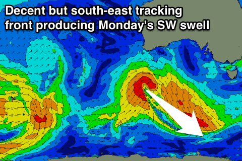
The groundswell will be produced by a strong but unfavourably and south-east tracking front firing up under WA today.
This isn't due to offer any major size, building to 2-3ft across Middleton and 3-4ft at Waits and Parsons into the afternoon, with 3ft or so of S/SE windswell. The swell should drop through Tuesday but conditions will remain poor and wind affected with a strong E'ly breeze, that may tend E/NE through the morning, back to the SE through the afternoon.
Into Wednesday we're looking at small leftover amounts of S/SW and S/SE swell and a deepening inland surface trough is due to start moving east, swinging winds back to the S'th across the South Coast. There's a chance for variable breezes early, but we'll have to review this Monday.
Looking at the end of the week, and some weak windswell is likely from Wednesday's change Thursday with onshore winds, ahead of a long-range and inconsistent SW groundswell for Friday but with what looks like to be onshore winds again. We'll have a closer look at this Monday.
Mid Coast: A slight kick in size is due Monday afternoon from the new SW swell to 1ft+, but this swell will quickly fade Tuesday from 0.5-1ft and then become flat Wednesday. There's an outside chance for some windswell Thursday from the change on Wednesday, but we'll review this Monday. Have a great weekend!

