Great Saturday, deteriorating Sunday, small windows next week
South Australian Forecast (issued Friday 23rd October)
Best Days: South Coast Saturday and early Sunday, South Coast Wednesday morning (possibly Friday morning)
Recap
Plenty of swell across the South Coast yesterday but with poor onshore winds, while the Mid Coast offered tiny peelers for keen surfers across the beaches and reefs. Today the swell was hanging in around 1ft+ on the Mid, while the South Coast saw a stronger S/SW groundswell providing solid 3-5ft waves across most locations with better but still less than ideal E/NE winds. SE sea breezes have since started to strengthen though, creating deteriorating conditions.
This weekend (Oct 24 – 25)
South Coast: Tomorrow will be the pick of the weekend with good amounts of swell easing from 3ft across the Middleton stretch and 4-5ft at Waits and Parsons under N/NE offshores, tending variable into the afternoon with only a slight chance of sea breezes.
Sunday will be clean early, but the winds only favourable for a limited period with a light NW breeze due to swing more W/NW through the morning ahead of a gusty W/SW change through the afternoon.
With smaller amounts of swell to 2ft+ at Middleton and 3-4ft at Waits, it's probably not worth the drive from Adelaide for just the early surf, but if already in the area, protected spots will be best.
Mid Coast: Today's S/SW swell is expected to ease through tomorrow from 1ft or so, before becoming tiny into Sunday with those average onshore winds.
Next week onwards (Oct 26 onwards)
South Coast: Next week isn't looking too good at all for the South Coast with plenty of swell but poor winds (Wednesday is the best chance for a wave with variable winds more than likely).
But coming back to Monday and Sunday afternoon's change will strengthen from the S/SE kicking up junky levels of S/SE windswell through the day.
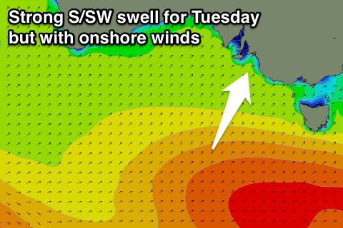
 Into Tuesday our strong pulse of S/SW groundswell is due, generated by a vigorous polar frontal system firing up through our southern swell window over the weekend.
The swell should peak at a good 3-4ft+ across Middleton with 5-6ft sets at Waits and Parsons, along with poor but easing fresh SE tending S'ly winds.
As the swell eases Wednesday, we could see a window of cleaner conditions as winds tend variable before picking up from the S'th again through the day.
A rapid drop in size is expected though from 3-4ft at Middleton and 4-5ft at Waits and Parsons, down to 2-3ft and 3-4ft respectively through the afternoon.
Winds may tend E'ly through Thursday morning but with small leftover amounts of swell ahead of another strong S/SW groundswell arriving through the day.
This swell will be generated later in our swell window by a less favourably aligned polar low (compared to the storm generating Tuesday's swell) but it will be stronger. As a result we'll see a touch less size from this system, building to 3-4ft at Middleton and 4-5ft at Waits through the afternoon as sea breezes kick in.
Mid Coast: With Sunday's onshore change, a tiny 0.5-1ft of windswell is expected into Monday, with the S/SW groundswell keeping stronger 0.5-1ft sets hitting the coast through Tuesday.
Tiny to flat conditions are then due into the rest of the week but with clean conditions.
Longer term there's nothing major developing on the charts, but we'll have another look at this on Monday. Have a great weekend!

