Great swell Sunday, easing and cleaner down South Monday
South Australian Forecast (issued Friday 16th October)
Best Days: Both coasts Sunday, South Coast Monday, Mid Coast for keen surfers Tuesday and Wednesday
Recap
Clean fun waves most of yesterday down South with offshore winds most of the day, tending stronger NW into the afternoon ahead of a late onshore change. The Mid was a tiny and wind affected 0.5ft yesterday morning, but into the afternoon winds eased and the swell kicked with the incoming tide, with good sets on the reefs and beaches.
Today the swell was back to 0.5-1ft with light variable winds across the Mid, and the South Coast continued to provide workable 2-3ft sets across the Middleton stretch with more size out at Waits and Parsons with early light winds.
This weekend (Oct 17 – 18)
South Coast: Similar amounts of swell to today are due across the South Coast tomorrow, but winds look dicey, lingering onshore from the S/SE but without too much strength, if you're desperate for a wave. Middleton will be the best option.
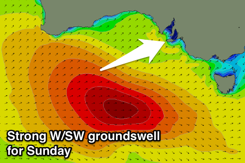
Sunday's strong W/SW groundswell is still on track, with the low producing the swell currently sitting south of WA, aiming a fetch of gale to severe-gale W/SW winds towards us.
The low will push east fairly quickly this afternoon and tomorrow while continuing to aim a fetch of gale to severe-gale W/SW winds through our western and then south-western swell window.
 The swell is expected to peak through the morning Sunday but persist most of the day at size, with solid 3-5ft waves across Middleton and 6ft+ sets at Waits and Parsons. Conditions are still a little dicey and not perfect with a morning E/NE-NE breeze creating workable and peaky waves ahead of S/SE sea breezes.
Mid Coast: Tiny 0.5-1ft waves are due to continue into tomorrow morning across the Mid, but into the late afternoon we'll probably see the first signs of the new W/SW swell due Sunday. This could see sets pushing up towards 1-1.5ft as afternoon sea breezes tend back to the S/SE late.
Sunday however looks great with good fun 2ft surf all day, with bigger bombs on the large incoming tide into the afternoon. Winds should be great most of the day as well.
Monday onwards (Oct 19 onwards)
South Coast: We'll see Sunday's swell drop away pretty steadily through Monday across both coasts, with Tuesday only due to see small leftovers.
Winds will improve further for the South Coast, with offshore N/NE tending variable breezes due Monday with easing 3ft to possibly 4ft sets at Middleton and 4-5ft waves at Waits and Parsons, down to 2ft+ and 3-4ft respectively into the afternoon.
Come Tuesday much smaller 1-2ft waves are due across Middleton and winds are tricky with a trough moving in from the west, bringing strengthening NW tending W/SW breezes.
This trough will be followed by a stronger S/SW change Wednesday linked with a weakening polar front projecting up towards us early to mid-next week.
This should produce a moderate sized increase in S/SW windswell Wednesday afternoon ahead of some stronger S/SW groundswell Thursday but with onshore S/SE winds.
Mid Coast: Sunday's swell is expected to drop back from 1-1.5ft Monday, but into Tuesday a mix of short-range and long-range W/SW swells are due. The long-range energy will be produced by a distant but strong low south-west of WA, with the short-range swell by a weak front pushing through the Bight Monday. It looks like we'll see 1-1.5ft waves, with the chance of the bigger 2ft bomb into the afternoon, but with onshore winds.
Wednesday's change from the frontal system should keep 1-1.5ft of windswell hitting the Mid, before easing back from 1-1.5ft Thursday. We'll have a closer look at this Monday though, have a great weekend!


Comments
Looking nice on the Mid this morning!
Bomb set just came through!