Window down South tomorrow, fun Mid Wednesday
South Australian Forecast (issued Monday 5th October)
Best Days: Early Tuesday before the change down South, Mid Coast Wednesday and Thursday, South Coast Friday morning
Recap
Great weekend of waves with clean fun surf down South Saturday and a building swell, with the Mid performing best Sunday with clean 2-3ft sets right until dark.
This morning the Mid was a wind affected 1-2ft, with small surf down South with the stronger offshore creating tricky and less than ideal conditions.
This week (Oct 6 – 9)
As Ben discussed on Friday, the fore-runners of a strong new W/SW groundswell should be seen this evening on the Cape du Couedic wave buoy in the 20s range. This swell was generated over the weekend by a strong frontal system moving in from the Indian Ocean, south of WA with satellite observations picking up sustained core wind speeds in the 50kt range.
This swell should peak tomorrow morning across both coasts, with solid 3-5ft sets across Middleton and bigger 6ft+ sets at Waits and Parsons, while the Mid is due to offer 2-3ft surf through the morning, with a late kick in similar sized W/SW windswell associated an onshore change.
Before this change though N/NW winds will favour the South Coast, with onshore W/SW breezes due to hit late morning. So get out early for the best conditions.
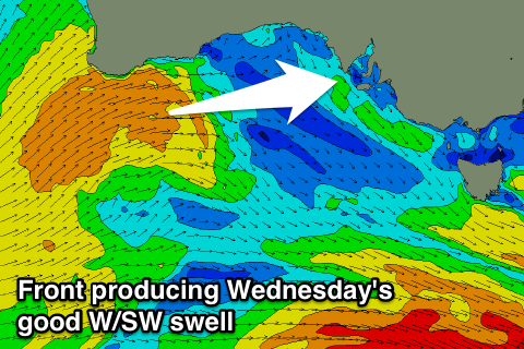
 A good short-range W/SW swell is due to peak through Wednesday across the Mid from the frontal system bringing tomorrow's onshore change. This front is producing a fetch of strong to gale-force W/SW winds while pushing in towards the Bight and should keep 2-3ft surf hitting the Mid through Wednesday as winds quickly swing back around to the SE as a ridge of high pressure moves in from the west.
The South Coast will continue to provide plenty of size but be poor with the fresh to strong SE breeze.
Into Thursday morning we'll fall in between swells ahead of a good new SW groundswell pulse for mainly the South Coast into the afternoon and Friday morning.
This will be produced by another strong frontal system tracking in east-southeast under WA over the coming days.
The Mid should hold 2ft sets all day and then back off from 1ft to possibly 2ft Friday morning, while the South Coast should see 3ft waves at Middleton through the morning, kicking a bit stronger later in the day.
Winds will slowly improve down South but remain less than ideal Thursday with a moderate to fresh E'ly, tending S/SE into the afternoon. Friday looks better with peaky clean waves under a likely morning NE'ly before sea breezes kick back in.
This weekend onwards (Oct 10 onwards)
The weekend is looking tricky and not too inspiring with small amounts of leftover swell under variable winds likely from the SE Saturday morning and then maybe W/SW to SW Sunday.
A new S/SW swell is expected to build Monday but with onshore winds due to persist, but we'll have a closer look at this through Wednesday.


Comments
Wow.. the Mid is solid this morning, some of the biggest groundswell lines we've had here in a while.
Looking amazing at Victor too - not huge down south but how's the corduroy!
Good swell here this morning as well, the sets made it a Bay paddle out rather than D St. It's been a while! the waves weren't that good but it was nice to see something bigger than 2'