Average tomorrow, fun from Friday and a great weekend
South Australian Forecast (issued Wednesday 16th September)
Best Days: Friday morning, Saturday and Sunday morning's down South, Monday both coasts winds pending, Tuesday Mid Coast
Recap
Lumpy and small surf yesterday with early light winds which actually deteriorated through the day, while the Mid offered workable 1-1.5ft waves if you were desperate.
Today a new S/SW groundswell is on the build down South with clean 2-3ft sets off Middleton and more size out at Waits but winds have since shifted fresh E'ly as the swell's continued to build, creating poor conditions. The Mid Coast is still clean but only tiny to 0.5-1ft.
This week and weekend (Sep 17 – 20)
Today's strong kick in S/SW groundswell is due to hold a similar size into tomorrow morning before easing through the day, but conditions will be poor with a moderate to fresh S/SW breeze lingering in the wake of an early morning change. There Mid could see an early S/SE'ly with a tiny 0.5-1ft of swell.
Friday morning will be much better with variable tending light offshore winds and another pulse of building SW groundswell from a strong fetch of pre-frontal W/NW winds swinging in from the Indian Ocean and under WA yesterday and today.
This should keep good 3ft sets hitting Middleton with 4-5ft sets at Waits and Parsons, kicking a little further into the afternoon but with sea breezes. The Mid Coast should see 1ft+ sets ideal for beginners.
The weekend is looking great down South with Friday's pulse of SW groundswell due to ease through Saturday under N/NE offshores and weak afternoon sea breezes. Middleton should offer good 3ft sets with 4-5ft waves out at Waits and Parsons, easing a touch through the day. The Mid should continue to offer 1ft+ sets.
 Into Sunday clean conditions are expected with a new SW groundswell from another strong pre-frontal fetch of gales moving through our swell window late this week.
This should keep fun 2-3ft sets hitting Middleton all day with 4ft+ waves at Waits, easing later in the day (1ft+ on the Mid). N/NE offshores are expected again ahead of weak sea breezes.
Next week onwards (Sep 21 onwards)
Our large SW groundswell due into Monday next week has unfortunately been downgraded a touch, with it also being more W/SW in nature.
This will be related to the vigorous polar front progression generating the swell pushing more up towards WA and then weakening. In saying this we should still see strong levels of W/SW groundswell but only into Monday afternoon/evening.
The Mid is due to see strong 2ft+ sets developing through the day, with the South Coast building to 3-4ft at Middleton and 5-6ft at Waits into the afternoon. Winds are a little unsure with the models diverging on the timing of a change due through the day, so we'll have to review this again on Friday.
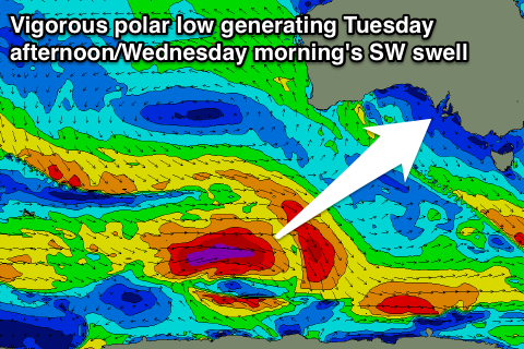
Into Tuesday afternoon we should see a stronger secondary pulse of SW groundswell, produced by a secondary polar low, projecting a fetch of severe-gale to storm-force W/SW winds east along the polar shelf through the weekend. This looks to be with fresh and gusty S/SE winds, but again we'll have another look at this Friday.

