Great weekend, larger windy swells next week
South Australian Forecast (issued Friday 7th August)
Best Days: Saturday and Sunday morning down South, Monday afternoon down South, Tuesday down South, Wednesday for a stormy on the Mid, Thursday both coasts
Recap
Early W'ly winds created workable conditions across the South Coast yesterday morning with a large easing S/SW swell, best around the Victor region, unless duckdiving a million times is your thing at Middleton.
Today was much cleaner and excellent down South with a light offshore and solid S/SW swell to 3-4ft at Middleton and bigger bombs out at Waits and Parsons. The Mid was also clean but tiny. Winds should remain favourable all day down South as the swell eases a touch further.
This weekend (Aug 8 - 9)
The weekend is still looking great down South with moderate amounts of swell tomorrow and light N'ly tending variable winds tomorrow, and a smaller fading swell Sunday under stronger N/NE winds.
Middleton should still offer inconsistent 3ft sets tomorrow with 4-5ft waves at Waits, dropping from a small 2ft+ Sunday morning along the Middleton stretch with 3ft+ sets at Waits early.

Next week onwards (Aug 10 onwards)
Monday morning will be tiny down South, but a strong new long-range SW groundswell is due to build through the afternoon generated by a vigorous polar frontal progression through the southern Indian Ocean the last few days.
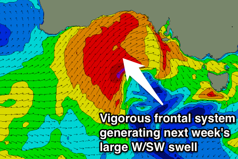
A much more consistent and solid increase in W/SW swell is also due through Monday as a frontal system shedding off the polar progression pushes up towards WA and then through the Bight towards us over the weekend.
A fetch of strong to gale-force W/SW winds will be aimed into us, kicking up a semi-stormy 3ft wave on the Mid Monday while the South Coast will see a limited increase in size later Monday. The mix of SW groundswell and W/SW swell should build to 3ft at Middleton with 4-5ft sets at Waits under fresh to strong W/NW winds (possibly swinging NW on dark).
The low will push off quickly to the east overnight leaving an easing mix of swells Tuesday down South with fresh to strong N/NW tending W/NW winds.
Another stronger cut-off low moving in from the west will kick up a building windswell across the Mid, back to 3ft during the afternoon.
A much larger and more powerful W/SW groundswell will fill in Wednesday from this low, generated by a fetch of gale to severe-gale W/SW winds through the Bight.
This should kick up large stormy swell to 3-5ft on the Mid Coast with strong SW tending W'ly winds.
The South Coast should see Middleton building to the 4-5ft+ range with 6-8ft sets at Waits, but stormy and improving later.
Thursday should be cleaner as winds ease and the swells ease, but we'll have a closer look at this Monday. Have a great weekend!

