Mix of swells and conditions to work around
South Australian Forecast (issued Wednesday 8th July)
Best Days: Thursday afternoon both coasts, Friday morning South Coast, Mid Coast Saturday and Sunday for keen surfers, protected spots South Coast Saturday, South Coast Tuesday morning
Recap
Protected spots were the best down South yesterday, with a fun easing swell and W'ly breeze, the Mid Coast offered 1-2ft waves which improved through the day as winds eased and tended more variable.
Today the surf was super fun and smaller down South with a light offshore tending variable wind, and 1ft to nearly 2ft on the Mid.
This week and weekend (Jul 9 – Jul 12)
 Tomorrow afternoon will be the pick for a surf across both coasts tomorrow, with small to tiny surf through the morning, and a new mix of W/SW swells for the afternoon.
The Mid Coast should build to an inconsistent 1-1.5ft, with 2ft to possibly 3ft sets developing at Middleton and 3-4ft+ waves at Waits under moderate to fresh N'ly tending lighter N/NW winds.
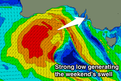
Friday should see the swell ease from a similar size with funky winds as a strong low starts pushing in from the west. This should kick up 1-2ft of windswell across the Mid with strengthening NW tending W'ly winds, while protected spots will be best down South.
Into the weekend, a solid increase in W/SW groundswell and SW windswell is expected across the Mid Coast as the low pushes in from the west, while the South Coast should see a fun pulse of W/SW groundswell from a pre-frontal fetch of W/NW winds under WA the coming days, ahead of a stormy mix of W/SW and S/SW swell from the low as it pushes across us.
The Mid Coast should build to a messy 3ft+ Saturday afternoon with fresh and gusty W'ly winds, while the South Coast should see 3ft waves at Middleton and 4-5ft sets at Waits Saturday morning, building further into the afternoon.
Come Sunday the Mid should ease from a stormy 3ft+ with strong but easing SW winds, while the South Coast will vary between 4-5ft at Middleton and the 6ft range at Waits but with those onshore SW winds.
Next week onwards (Jul 13 onwards)
The weekend's stormy mix of swells are due to ease through Monday but conditions are due to remain poor with a fresh but easing S/SW'ly across both coasts.
Into Tuesday a moderate sized S/SW groundswell is due, generated by a strong polar front firing up under WA Friday and through the weekend.
This should produce a good 3-4ft+ wave at Middleton with 5ft+ sets at Waits and Parsons and tiny 1ft waves on the Mid with NW tending SW winds. We'll review this again Friday though.
Longer term some larger SW groundswell is on the cards for later next week from broad and sustained frontal activity along the polar shelf, but we'll look at this again Friday as well.

