Great week ahead for the South Coast (besides Thursday)
South Australian Forecast (issued Monday 29th June)
Best Days: Every day down South besides Thursday
Recap
The weekend played out to plan, with the first pulse of inconsistent but strong W/SW groundswell peaked through Saturday with great 3-4ft waves across Middleton with larger and stronger sets at Waits and Parsons under excellent offshore winds. The Mid Coast was a small and inconsistent 2ft with good conditions most of the day.
The swell held a similar size into Sunday, if not a bit bigger with great conditions across both coasts under local offshores. Into the afternoon though a mix of stronger and inconsistent W/SW groundswell filled in with some larger and more consistent SW swell, pulsing solidly across the South Coast under persistent offshore winds.
This swell peaked overnight and eased back into this morning but still offered solid 3-5ft waves across the Middleton stretch with much bigger sets at Waits and Parsons under variable winds, while the Mid eased from an inconsistent 2ft.
 This week and weekend (Jun 30 – Jul 5)
The coming week will be great across the South Coast with favourable winds (besides Thursday) and plenty of swell.
Firstly, tomorrow will see the weekend's swell continue to ease, with Middleton due to drop from 3ft+ with 4-5ft sets at Waits under N'ly tending variable winds. The Mid is expected to be tiny and easing from 1ft+.
A reinforcing SW groundswell is due Wednesday morning down South, generated by a pre-frontal fetch of W/NW gales under West Oz and the Bight yesterday and today.
This should kick Middleton back to 3-4ft with 5ft+ sets at Waits and Parsons during the morning before easing into the afternoon under moderate to fresh NW tending W/NW winds.
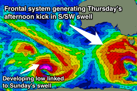
A strong cold front is due to move in from the west over the coming days, aiming a fetch of gale to severe-gale W/SW tending SW winds through our swell window, while also bringing an onshore change to the South Coast Thursday.
Fresh but easing S'ly tending S/SE winds are due as the S/SW groundswell from the front fills in, building to 4-5ft at Middleton into the afternoon, with 6ft sets at Waits and Parsons. The Mid Coast is only due to see 1ft waves due to the southerly swell direction.
Friday should be much better on the South Coast as the swell drops away under N/NE tending N/NW winds as a weakening cold front approaches from the west.
Saturday will become smaller again as the swell continues to ease, with Middleton due to drop from 2-3ft with 4ft sets at Waits under offshore N/NW winds.
Into Sunday a good new S/SW groundswell should fill in across the South Coast, produced by a strong polar low developing south-southwest of WA Wednesday evening before swinging up and into Tassie towards the weekend.
This should produce a good but inconsistent S/SW groundswell, building to 4-5ft across most locations, with 6ft sets likely at Waits and Parsons. Conditions look as if they'll remain great down South with a fresh N/NW'ly persisting all day, but we'll confirm this on Wednesday.
Longer term a strong new W/SW groundswell is on the cards for Wednesday week, but check the next update for more info on this.

