Poor end to the week, great weekend
South Australian Forecast (issued Wednesday 17th June)
Best Days: Saturday and Sunday down South, Tuesday both coasts, Wednesday South Coast
Recap
Small, glassy and super fun waves at exposed beaches on the South Coast yesterday, with tiny surf on the Mid Coast.
Today a mix of swells are on the build but conditions were average down South with an onshore breeze, while the Mid was a tiny and lumpy 0.5ft but some bigger sets are now showing across the coast to 1ft or so.
This week and weekend (Jun 18 – 21)
Not the best end to the week at all, with plenty of swell due across the South Coast tomorrow but with a fresh to strong S/SE wind. The Mid Coast should see cleaner conditions with an inconsistent SW groundswell in the 1ft range.
Friday will remain poor as winds swing more E/SE across the South Coast with a mix of easing junky S/SE windswell and SW groundswell.
 The weekend is much more interesting with a large and powerful long-period but infrequent S/SW groundswell due Saturday.
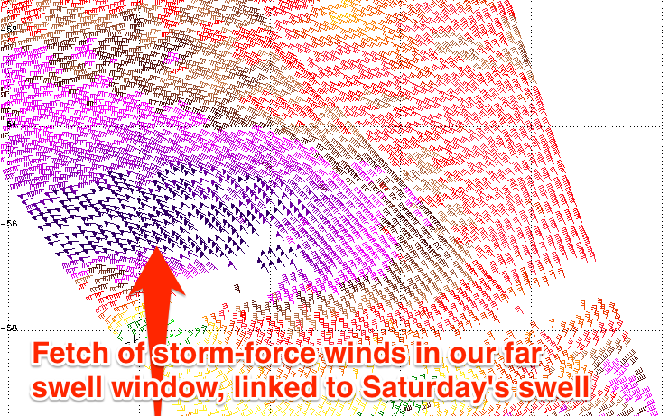
The intense polar low generating the swell has already produced a fetch of storm-force W'ly winds in our far swell window, registered by satellite.
This polar low is continuing east while aiming a fetch of severe-gale W/SW winds through our swell window, generating a large and inconsistent S/SW groundswell for Saturday (peaking through the morning).
Middleton should see inconsistent 4-6ft sets with larger 6ft+ waves at Waits and Parsons and other exposed spots under moderate to fresh N/NE winds. The Mid Coast should see infrequent 1ft+ sets, ideal for beginners.
The swell should drop into the afternoon and then further into Sunday, with Waits and Parsons likely to be too large at dawn, but more manageable for experienced surfers from midday or so. Strengthen N'ly tending N/NW winds will become a little tricky to deal with after lunch. This should also kick up a weak windswell across the Mid Coast.
Next week onwards (Jun 22 onwards)
A small reinforcing S/SW groundswell is due Monday morning across the state but this will be overshadowed by a more noticeable increase in S/SW windswell related to a strong onshore S/SW change overnight Sunday.
This should kick up a junky 2ft of windswell on the Mid Coast with junky 3ft+ surf down South.
This change will be related to another strong polar low, with a large S/SW groundswell due to fill in overnight Monday and peak Tuesday across both coasts. At this stage the swell looks to be similar in size to Saturday's with improving winds, most likely variable, as a ridge of high pressure moves in from the west. We'll have a closer look at this Friday though.

