Average week, large and offshore over the weekend
South Australian Forecast (issued Monday 15th June)
Best Days: Tuesday morning for keen surfers, Friday morning South Coast, Saturday South Coast, Sunday South Coast
Recap
Another fun weekend of waves across the South Coast with exposed beaches the pick under winds from the north-eastern quadrant.
Today the swell bottomed out with exposed spots the only real option for a decent wave.
This week (Jun 16 – 19)
Tomorrow will remain small with inconsistent 1ft to occasionally 2ft sets across Middleton with 2ft to sometimes 3ft sets at Waits and Parsons. Winds are a little funky though as a deepening surface trough starts pushing in from the west. Early should be clean with a variable breeze, with an increasing onshore through the day.
Come Wednesday a stronger S'ly change is due with a mix of building windswell and long-range SW groundswell.
This groundswell should provide tiny peelers on the Mid into the afternoon to 1ft as winds tend S/SE, while the South Coast will be a mess with 2-3ft waves developing at Middleton and 3-5ft sets at Waits and Parsons.
The long-range groundswell is due to ease into Thursday along with the S/SE windswell across the South Coast but conditions will remain poor with a fresh but easing SE tending S/SE breeze. The Mid will be clean but only around 1ft or so.
Friday will be worth a surf with the swell easing from a peaky 2-3ft at Middleton and 3-4ft+ at Waits and Parsons under light morning NE winds.
 This weekend onwards (Jun 20 onwards)
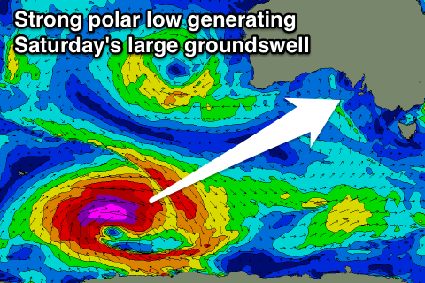
We've got a large and powerful S/SW groundswell due on Saturday, generated by a vigorous polar low firing up south-west of Western Australia, generating a fetch of severe-gale to storm-force W/SW winds as it pushes slowly east during this week.
A large, long-period S/SW groundswell will fill in through Saturday and peak to 5-6ft at Middleton with 6-8ft sets at Waits and Parsons as well as offshore reefs under NE-N/NE winds. The Mid isn't due to see any major size with 1-1.5ft sets at the swells peak.
A drop in swell is then due into Sunday and Monday as winds strengthen from the N/NW. More on this Wednesday though.

