Great weekend down South, larger next week but with average winds
South Australian Forecast (issued Wednesday 3rd June)
Best Days: Friday afternoon, Saturday both coasts, Sunday down South, Monday down South, early Tuesday down South, Wednesday both coasts
Recap
Easing and still chunky surf yesterday down South with favourable winds for most of the day, while the Mid was tiny and generally clean. Today was even better with a fresher offshore and smaller swell opening up more exposed beaches for a surf. The swell should continue to ease through the day as offshore winds persist.
This week and weekend (Jun 4 – Jun 7)
Smaller surf is due into tomorrow leaving exposed beaches on the South Coast with the only decent waves, but a fresh to strong N/NW breeze at dawn is due to swing more W/NW by mid-morning ahead of an onshore change around midday, so it's probably not worth the drive from Adelaide.
This frontal system should kick up an afternoon increase in W/SW swell across both coasts, reaching 2ft on the Mid but with poor conditions and 2ft at Middleton with 3-4ft sets at Waits and Parsons.
This swell should hold into Friday morning, but a new long-range W/SW groundswell should also arrive later in the day, generated in our far western swell window in the south-eastern Indian Ocean over the past couple of days.
The Mid Coast should continue in the 2ft range with 2-3ft sets at Middleton and 3-4ft waves at Waits and Parsons. Winds will be poor at dawn and fresh from the SW, but this should ease rapidly during the day and tend variable into the afternoon, creating fun conditions across both coasts into the evening.
The weekend is looking great down South and fun on the Mid Saturday with offshore winds and moderate but inconsistent amounts of W/SW groundswell.
This will be from the frontal activity in our far swell window, with the most size due into Saturday afternoon.
The Mid should continue to offer 2ft sets both Saturday and Sunday with NE winds on the former, creating the cleanest conditions. NW winds on Sunday will create bumpy and choppy surf.
The South Coast should be clean with the swell building to an inconsistent 3ft to occasionally 4ft at Middleton through Saturday with 4-6ft sets at Waits and Parsons, easing back from a slightly smaller size Sunday morning. Moderate N/NW winds are due through Saturday with fresh to strong NW winds Sunday.
 Next week onwards (Jun 8 onwards)
The Long Wave Trough will move in from the WA region, across us early next week, and with this we'll see the frontal activity focussed more in our swell window and into Victoria.
An initial strong but patchy frontal system is due to move in from the west during the weekend, projecting a fetch of gale to severe-gale W/SW winds through our western swell window.
This should generate a moderate to large sized W/SW groundswell for Monday, building to 2ft to possibly 3ft during the afternoon on the Mid and 4-5ft at Middleton with 6ft+ sets at Waits and Parsons.
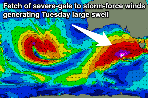
A secondary stronger frontal system pushing in from the west will intensify late in our swell window, aiming a stronger fetch of severe-gale to storm-force winds into Victoria.
We'll see a large SW groundswell pushing up from this system, filling in Tuesday and probably peaking through the day to 4-6ft at Middleton and 6ft to occasionally 8ft at Waits, while the Mid should be back to the smaller 2ft range.
Winds on Monday look good for protected locations with a fresh and gusty W/NW breeze all day, while Tuesday will see early W/NW winds give into an onshore SW change through the morning, creating poor conditions. Come Wednesday when the swell eases lighter more variable winds are due, but more on this Friday.

