Great weekend down South, then Tuesday/Wednesday
South Australian Forecast (issued Friday 29th May)
Best Days: Saturday and Sunday morning down South, Tuesday and Wednesday down South
Recap
Great surf down South yesterday with a new SW groundswell and all day offshores. The Mid Coast offered inconsistent 1-1.5ft waves with the odd 2ft set but with less than ideal conditions.
Today a large and powerful SW groundswell has filled in with offshore winds and pumping conditions down South with east 6ft+ sets across exposed breaks. The Mid Coast was a smaller 2ft+ but some bigger sets were seen on the incoming tide. Winds are workable as well with a light to moderate onshore breeze, while winds have gone light onshore on the South Coast.

This weekend and next week (May 30 – Jun 5)
Today's large and powerful SW groundswell is expected to ease through the weekend and conditions will be great for protected locations down South with a fresh NW tending W/NW breeze. The easing trend will be slowed by some smaller but strong reinforcing groundswell pulses, keeping Waits and Parsons out of the question most of the weekend.
Middleton should ease from 4-5ft with 6ft+ sets at Waits and Parsons Saturday with smaller 3-5ft waves at Middleton Sunday morning with 6ft sets still out at Waits. Winds will be workable in protected locations Sunday morning with a W/NW breeze, but an onshore change is due early afternoon, creating poor conditions into the afternoon. The Mid Coast should hang around 2ft all weekend but be bumpy and onshore.
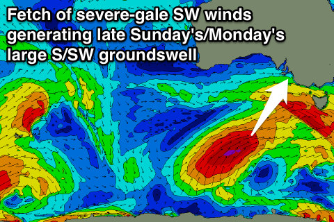
A late increase in large S/SW groundswell is likely down South Sunday, generated by a vigorous polar front pushing up and into Victoria tomorrow. A fetch of severe-gale SW winds will be projected through our southern swell window, with the swell due to arrive late Sunday, kicking to 6ft+ across most breaks.
Unfortunately a peak is now expected overnight with the swell easing back from 6ft+ Monday morning. The Mid Coast won't see any meaningful size with tiny 1ft surf due.
Monday will be onshore as well with a light to moderate S/SE breeze (that may tend variable through the morning) while the Mid will be clean but again tiny.
Tuesday and Wednesday will be the days to surf down South as winds swing offshore from the N/NE on the former and then strengthen from the N'th through Wednesday. Most locations should ease from 4-5ft Tuesday morning, with Middleton easing from 2-3ft Wednesday with 2-3ft+ waves at Waits and Parsons.
Come Thursday the surf will be tiny but clean early down South ahead of an onshore change. This onshore change may bring with it an increase in W/SW swell across the Mid during the afternoon, kicking to 2ft+ late in the day and easing from 2-3ft Friday morning, but the models are divergent on the strength of this system.
Long term a new long-range W/SW groundswell is due later Friday and more so Saturday, generated in the southern Indian Ocean by a vigorous polar frontal progression, but it will break down south-west of WA resulting in a lot of swell decay. We'll have a closer look at this on Monday though. Have a great weekend!

