Plenty of swell but with poor conditions
South Australian Forecast (issued Monday 18th May)
Best Days: Tuesday, late Wednesday for tiny peelers on the Mid, Saturday morning, Sunday, Monday down South
Recap
Great waves down South all weekend with fun amounts of swell and morning offshores that only tended more E'ly into the afternoon, keeping conditions relatively clean.
Today the South Coast was clean again but easing from a small 1-2ft at Middleton with bigger sets out at Waits and Parsons. The Mid Coast was flat and choppy with the northerly breeze.
 This week (May 19 - 22)
Tomorrow will be the pick of the period as winds are due to go onshore from Wednesday and persist into the end of the week before improving over the weekend.
This is a shame as there's some good pulses of swell on the cards for this week, the first and smallest due tomorrow, and from the S/SW. This was generated by a vigorous polar forming late in our swell window over the weekend, but we should see still Middleton coming in at an inconsistent 3ft on the sets with 3-4ft waves at Waits under fresh N/NW tending NW winds.
Come Wednesday a much stronger SW groundswell is due to fill in, generated by a vigorous polar front pushing up and into us from the south of WA.
This should build to a bigger 3-5ft at Middleton with 4-6ft sets at Waits into the afternoon, but winds will be onshore and fresh to strong from the S/SW tending S/SE.
This will create cleaner conditions on the Mid though, and the swell should build to 1-1.5ft through the afternoon/evening.
A drop in size is due through Thursday but winds will continue from the S/SE, limiting options again. The Mid will be clean but tiny and to 1ft or so.
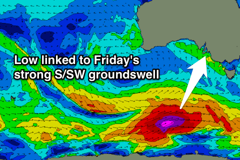
A final pulse of strong S/SW groundswell is due into Friday from a vigorous polar low generating a fetch of severe-gale to near storm-force W/SW winds through our southern swell window tomorrow and Wednesday.
This should generate a large S/SW groundswell for Friday that should peak through the early afternoon/afternoon to 4-6ft at Middleton with 5-6ft+ waves at Waits and Parsons. The Mid will be tiny with the southerly swell direction limiting it to 1ft.
Winds should improve a touch into Friday with a moderate to fresh E'ly breeze through the morning, before swinging SE into the afternoon.
This weekend onwards (May 23 onwards)
Friday's swell is due to ease through Saturday and Sunday, with a smaller reinforcing S/SW groundswell for Monday.
Winds will slowly improve and swing NE through Saturday and N/NE Sunday and Monday.
Middleton should ease from 3-5ft with the odd bigger set at Waits Saturday morning, dropping further from 3ft at Middleton and 3-5ft at Waits Sunday morning.
Longer term there's nothing too significant on the cards for next week at this stage but winds look favourable for exposed breaks. More on this Wednesday.


Comments
Great looking day down South today before the onshores hit tomorrow.
Photo by http://instagram.com/cyan_sandy