Great run for the Mid
South Australian Forecast (issued Wednesday 15th April)
Best Days: Late Thursday on the Mid for beginners, Friday both coasts, Saturday morning South Coast, Sunday Mid, Monday both coasts
Recap
Small clean waves only surfable at exposed breaks yesterday and we saw similar conditions this morning before an onshore change moved through just before lunch.
 This week and weekend (Apr 16 – 20)
Tomorrow will be a lay day down South as the swell remains small and onshore S/SE winds create poor conditions.
The Mid Coast will be tiny, but a late lift in swell to 1ft+ is due into the afternoon/evening, so it'll be worth keeping an eye on the South Port cam for a late slide on the log.
Into Friday two separate but good W/SW groundswells are due across both coasts, generated by a couple of vigorous polar lows firing up through our swell window since the weekend.
Friday afternoon should reveal the most size with the Mid Coast coming in at 2ft+ while the South Coast should build to 3-5ft at Middleton and 6ft at Waits before peaking overnight and easing Saturday. The Mid should hold around 2ft while the South Coast should ease from 3-4ft at Middleton and 5-6ft at Waits.
Winds will be best for the Mid Friday and offshore from the E/SE, while the South Coast will be peaky with a morning E/NE'ly.
Saturday looks poor on the Mid with a moderate W'ly tending fresh to strong SW wind, while the South Coast should be good in protected locations through the morning with a W/NW'ly ahead of the SW change just after lunch.
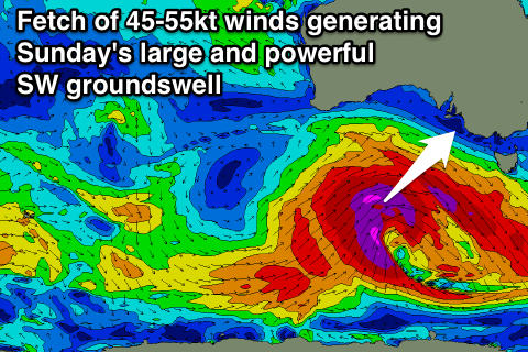
Later in the day Saturday we may see signs of a large and powerful SW groundswell due Sunday, generated by a vigorous and broad polar low firing up under the influence of a strong node of the Long Wave Trough moving in from the west.
This low will project a fetch of severe-gale to storm-force W/NW and then W/SW winds through our swell window, producing a large, long-period and very powerful SW groundswell for Sunday.
The Mid Coast should offer good 3ft+ waves all day while the South Coast will be huge and around 6-8ft at Middleton with bigger 8-10ft sets at offshore reefs and other exposed breaks.
Strong S/SE winds will create poor conditions down South however, with the Mid the pick under offshore SE tending S/SE winds.
A reinforcing S/SW groundswell is due Monday morning across the South Coast, generated on the tail of the vigorous polar low and this will keep large but easing surf hitting the region through the day before fading further Tuesday.
Winds should improve and swing to the NE down South and remain offshore for the Mid, with better N/NE winds into Tuesday.
Longer term we may see some better SW groundswell into the end of the week, but we'll have a closer look at this on Friday.

