Plenty of swell with less than ideal winds
South Australian Forecast (issued Wednesday 1st April)
Best Days: Friday morning for keen surfers in protected spots down South (beginners on the Mid), Saturday morning down South, Sunday morning down South for keen surfers, early Monday down South
Recap
A strong pulse of SW groundswell filled in yesterday with offshore winds across both coasts producing pumping waves down South, while the Mid picked up some bigger than expected 2ft sets.
Today the surf was still pumping down South but easing slowly with a light offshore wind, but this has since become strong to gale-force from the NW. The Mid Coast was smaller, but a building NW windswell is breaking across most spots with a fresh to strong N'ly wind.
This week (Apr 2 – 3)
Tomorrow will be poor across both coasts with tiny clean waves on the Mid and poor onshore slops across the South Coast under a strong SE breeze.
The windswell that was due to be whipped up by tomorrow's onshores is now quite smaller, with the fetch below us being more SE, which isn't great for generating any major size.
Instead we're looking at moderate amounts of S/SE windswell tomorrow, fading through Friday from a small 2ft+ or so during the morning. Winds should be workable for protected locations with a moderate to fresh E/NE'ly.
The Mid Coast is expected to see a slight kick in swell later Thursday and Friday morning to 1ft from a weak front currently under WA, ideal for beginners.
 This weekend onwards (Apr 4 onwards)
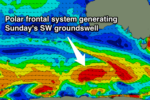
Two good pulses of SW groundswell are due through Saturday and Sunday. The first and smallest will be generated by a strong and broad pre-frontal fetch of W/NW winds developing south of WA today, pushing east towards Tassie through tomorrow.
The swell will be inconsistent but fun, building to 2-3ft at Middleton Saturday afternoon with 3-4ft sets at Waits and Parsons.
Right behind this fetch of pre-frontal W/NW winds will be a better aligned fetch of W/SW gales, pushing east along the Polar Shelf.
A secondary inconsistent SW groundswell should arrive from this source, peaking Sunday morning Sunday to a better 3ft+ at Middleton and 4-5ft at Waits and Parsons. The Mid isn't expected to see any real size at all.
Winds will be best down South Saturday morning with a NE offshore before sea breezes kick in. Sunday looks dicey but workable with a light to moderate SE'ly before freshening from the S/SW through the day.
A slight drop in size is due through Monday and we should see a short window of clean conditions through the morning with a variable breeze before a strong surface trough moves in from the west, bringing a vigorous S'ly change.
This change will spoil a new SW groundswell due on Tuesday, with a solid windswell in the mix along with fresh to strong but easing S/SE winds.
The end of the week should be better with a new long-range S/SW groundswell due Thursday/Friday as winds slowly swing back to the NE, but more on this Friday.

