Typical summer fare in South Oz
South Australian Surf Forecast by Ben Matson (issued Tuesday 27th January)
Best Days: No great days. Maybe late Friday or early Saturday for a small longboard wave on the Mid Coast.
Recap: Plenty of fun waves over the weekend - a good groundswell across both coasts Saturday with W/NW tending W’ly winds, slowly easing swell through Sunday and Monday with Sunday offering bumpy surf everywhere under a fresh SW breeze, and Monday providing small clean waves on the Mid Coast with light winds. Poor at Victor today with onshores, and tiny clean residual lines on the Mid.
This week (Jan 28 onwards)
We can safely write off the prospects of anything good down south for the rest of the week, thanks to a persistent south-east wind regime. There are no notable new swells due anyway - a small SW groundswell Wednesday/early Thursday, but only suited size wise to exposed beaches.
Unfortunately, surf prospects for the Mid Coast aren’t good either. We’re likely to see tiny residual swell both Wednesday and Thursday; Wednesday’s new groundswell is likely to be too south in direction for the gulf and it’s not expected to be very large anyway. So, anticipate occasional teaser lines under a foot for the most part.
Friday does have an interesting new swell on the cards, but I’m really not confident in whether we’ll see anything appreciable on the Mid Coast.
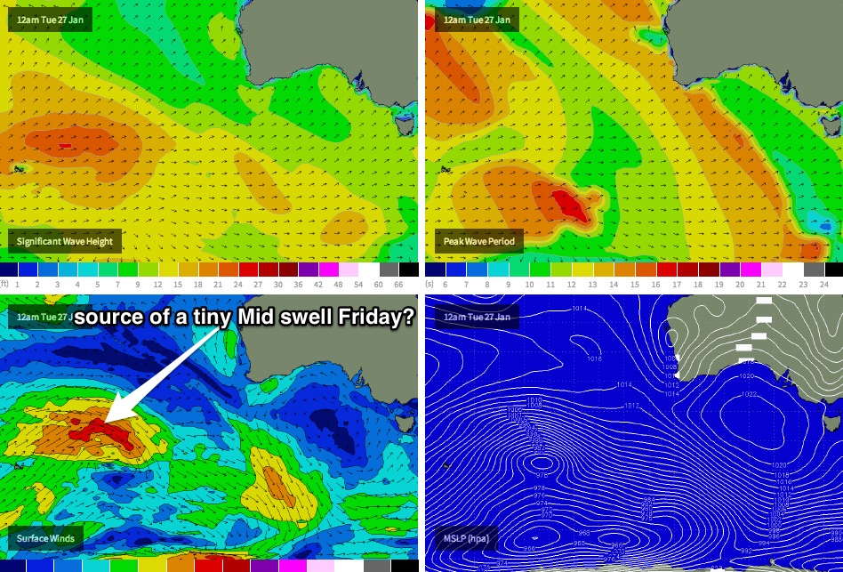
A broad front and low is currently tracking near the region of Heard Island (see chart below), within a narrow zonal flow between 40-50S. This system is expected to generate a new W/SW event, with the leading edge arriving early/mid morning, ahead of a building trend into the late afternoon before an overnight peak (or perhaps early Saturday).
What I don’t like about this system is that core wind speeds are not expected to be very strong, and also that it's expected to do most of its swell production east of 100E - a very long way from the mainland.
So while we will probably see some good period value at the Cape du Couedic buoy on Friday, I don’t have high hopes that it’ll translate to much at the beach. For now, expect a late pulse to 1.5ft across the reefs with some tidal assistance (conditions will be good though with offshore breezes).
I’ll keep a close eye on its developments on Friday and will update in the comments below as required.
This weekend (Jan 31 - Feb 1)
Friday’s late new swell should probably hold through Saturday with small teaser lines persisting across the Mid Coast in the 1-1.5ft range for much of the day, with smaller surf expected on Sunday. Conditions should remain clean with SE winds.
This airstream will continue to destroy surf conditions down south, so don’t worry about a weekend road trip. What swell will be in the water will be nothing more than short range S/SE windswell.
Next week (Feb 2 onwards)
Nothing major on the charts for next week at this stage. A small polar low (and a couple of follow up systems) are expected to squeak through the eastern periphery of the South Coast’s southern swell window over the weekend, and may set up a minor S/SW swell for the first half of next week - but I fear they’ll develop too far east and aim the swell up into the Tasman Sea.
Otherwise, our broader swell window will be under the influence of a blocking pattern - which is perfectly normal for this time of year - but the upshot of this is mainly small swells, where you’ll have to work around small windows of opportunity in the local wind field. I can’t see anything worthwhile yet! See you Friday.


Comments
Nothing showing on the CdC buoy right now (ie no leading edge) so we can safely write off the chances for a late afternoon pulse on the Mid.
Model data forecast the leading edge due in at midnight last night (19 seconds) so it's either running extremely late, or never really developed properly at all (the latter most likely, as it was a relatively small system in a flukey part of our swell window anyway).