Great Mid Coast Sunday afternoon, plenty of waves through to Tuesday
South Australian Forecast (issued Friday 21st November)
Best Days: Saturday morning down South, Sunday both coasts (Mid into the afternoon) Tuesday Mid Coast
Recap
Fun small waves across the South Coast yesterday morning with fresh to strong NW winds, while today a touch more size was seen across the region with a new SW swell filling in with sets to 3ft at Middleton and bigger waves out at exposed breaks. Winds were favourable and offshore across the South Coast again this morning, while the Mid was a tiny and lumpy 1ft, but has since kicked to 1-1.5ft with the incoming tide.
 This weekend and next week (Nov 22 – 28)
We've got a fun weekend of surf ahead with both coasts performing well at stages.
Today's small uptick in size will ease off through tomorrow across both coasts and the South Coast will be the pick during the morning with an offshore N'ly wind ahead of a fresh and gusty SW change through the afternoon.
Middleton should be easing from 2ft+ with 3ft to occasionally 4ft sets early out at Waits and Parsons.
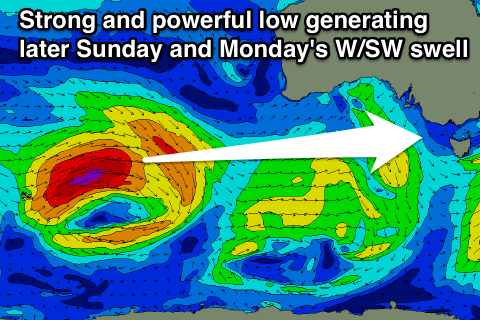
Of greater significance is the arrival of a strong but inconsistent W/SW groundswell through Sunday from our far swell window between Heard Island and West Oz.
A vigorous polar low has produced a large groundswell for WA, which will push across to us and fill in strongly through Sunday.
This low has since weakened but is still generating a fetch of strong to gale-force W/SW winds under WA which will break down further through this evening.
This will help bump up the size through Sunday afternoon, with the Mid Coast due to build to 2ft to nearly 3ft while the South Coast should see 3-4ft sets at Middleton and 5ft+ waves out at Waits.
Winds look great with light variable breezes due to swing locally offshore across both coasts Sunday morning ahead of weak afternoon sea breezes.
Come Monday the W/SW swell should be still kicking around 2ft across the Mid Coast, while a secondary front pushing up through the Bight over the weekend will see Tuesday morning holding 1-2ft before easing through Wednesday.
The South Coast should ease gradually through Monday with an uptick in size through Tuesday with a new SW swell but unfortunately winds will be onshore from Monday morning as a SW change moves through followed by a high resulting in S/SW winds Tuesday and S/SE winds Wednesday.
The Mid however should see S/SE winds Tuesday and SE tending S'ly winds Wednesday.
Longer term there's nothing major on the cards as a large blocking high sits over us through most of next week, deflecting frontal systems away from our prime swell window. This will also deliver a week or so of poor winds to the South Coast as mentioned above, so make the most of the coming days of waves. Have a great weekend!

