Good South Coast Wed/Thu, bigger swell over weekend
South Australian Forecast (issued Monday 6th October)
Best Days: Wednesday and Thursday down South, Saturday both coasts, early Sunday South Coast
Recap
Saturday was great down South with a solid easing S/SW swell and fresh offshore winds that persisted until the late afternoon. The Mid Coast was poor with a tiny swell and choppy conditions.
Sunday was a write-off down South with fresh onshore S/SE tending E/SE winds, while the Mid was clean all day and offered good waves into the afternoon/evening with a fresh pulse of SW swell to 1-2ft.
Today, the swell has dropped back to a tiny and choppy 1ft+ on the Mid, while the South Coast was clean with the easing swell from the 2-3ft range under strengthening N/NW winds. A strong W/SW change is due through the mid-afternoon, writing off the surf for the rest of the day while also kicking up a late increase in windswell cross the Mid.
This week (Oct 7 - 10)
Tomorrow will be a day to miss with fresh onshore W/SW winds expected to linger in the wake of this afternoon's change, although there'll be more swell around than today. The Victor region may see an early W'ly but it won't be worth the drive from Adelaide. The Mid Coast should see weak 1-2ft waves with improving conditions through the afternoon as onshores ease.
Through the rest of the week a series of SW groundswell pulses are due across the South Coast generated by a couple of unfavourably aligned but broad fronts pushing under the country over the coming days.
SW swell will spread up radially into the South Coast, with a first pulse Wednesday to 3ft at Middleton and 4ft+ at Waits expected to hold into Thursday morning before easing and then being followed up by a touch smaller pulse Friday. The Mid Coast isn't expected to see any major size above 1ft.
Conditions are looking good Wednesday and Thursday, but Thursday will be the pick with straight offshore N'ly winds through the morning ahead of a shift to the W/NW through the afternoon. Wednesday will see NW tending SW winds.
Come Friday an overnight change Thursday will linger from the SW but without too much strength, creating average conditions.
 This weekend onwards (Oct 11 onwards)
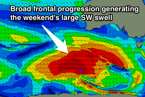
As talked about the last few updates, a strong node (peak) of the Long Wave Trough is expected to move in from the west later this week, bringing with it a broad, strong and vigorous polar frontal progression.
With this we should see a large SW groundswell generated, at this stage building through Saturday and peaking Sunday. Winds are a bit of an issue though with an onshore S'ly change likely Sunday, but we'll review this over the coming updates.

