Pumping Thursday/Friday morning, large but tricky weekend
South Australian Forecast (issued Wednesday 25th June)
Best Days: Thursday, Friday morning, Saturday morning and early Sunday down South, Friday afternoon and Saturday for stormy waves on the Mid
Recap
Monday's stormy increase in windswell across the Mid Coast backed off from a solid 3-4ft+ as winds also eased, but a large and powerful S/SW groundswel filled in down South, coming in at 6-8ft across exposed breaks. The Cape du Couedic Wave Buoy also showed incredible figures yesterday morning with maximum wave heights hitting 15m!
Conditions were only favourable in super protected locations though with a strong W'ly tending W/SW breeze.
Today the swell has backed off across both coasts but conditions were better down South with moderate to fresh W/NW winds.
This week (Jun 25 - 27)
Tomorrow and especially tomorrow afternoon is looking great on the South Coast as a strong SW groundswell fills in and winds clock offshore from the NW.
The swell is currently being generated by a vigorous frontal system passing under the Bight, aiming a fetch of severe-gale to storm-force W/SW winds through our south-western swell window.
Middleton should build to 5-6ft through the mid-late afternoon with 6-8ft sets at Waits while the Mid Coast should continue in the semi-stormy 2-3ft range. The morning will be clean down South with a W/NW breeze but the afternoon looks great for a hunt around the region.
A drop in size is expected across the South Coast through Friday as strong to gale-force N/NW winds swing W/NW through the afternoon. This will kick up a fresh stormy swell on the Mid Coast, building to 3-4ft into the afternoon with the gale-force onshore winds.
This weekend onwards (Jun 28 onwards)
The weather system linked to the Mid Coast's building stormy swell on Friday is a vigorous mid-latitude low pushing in from WA and this will generate another large pulse of W/SW groundswell followed by a S/SW groundswell for the Mid and South Coasts over the weekend.
The W/SW groundswell will be from a fetch of W/SW gales pushing through the Bight and will be hidden under a more localised stormy 3-4ft+ of windswell across the Mid Coast on Saturday.
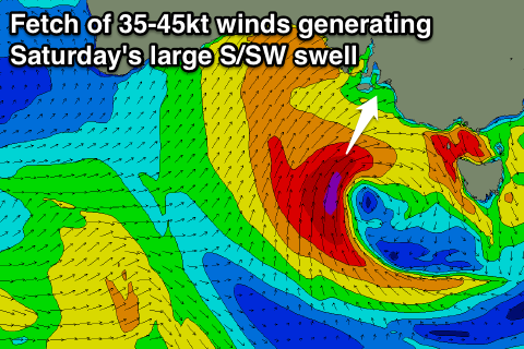
 The S/SW groundswell should be produced as the low pushes across us Friday evening stalls and projected a stronger fetch of severe-gales up into the South Coast early Saturday.
This should kick up a large S/SW groundswell for later Saturday, reaching 6-8ft across most spots down South before peaking overnight and easing from 6ft+ Sunday morning.
Protected locations will offer the best waves with a strong W/NW tending SW breeze on Saturday and then early W'ly tending SW winds on Sunday.
Into next week things will start to settle down but winds look to remain onshore until about Tuesday, when they should tend more variable as a ridge of high pressure moves in from the west. We'll confirm this on Friday though and in the meantime make the most of the large swells and favourable winds.

