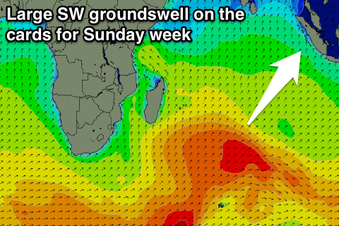
Good sized swells for the week, slower early next week then some better SW swell
Nias, Mentawai, South Sumatra forecast by Craig Brokensha (issued Tuesday 3rd May)
Best Days: Every day over the coming period
This coming week and weekend (May 2 - 8)
A good mix of S'ly groundswell and building SW swell are breaking across the region today and we'll see the SW swell peaking through tomorrow as the S'ly swell starts to ease.
Exposed breaks should pick up good 4-6ft waves tomorrow, easing back slowly from a similar size Thursday morning, down further Saturday and Sunday.
As the SW swell eases, a strong new long-period S'ly groundswell is due to fill in, produced by a vigorous polar low on the edge of our swell window the last few days.
This swell is due to build later Thursday, coming in at 3ft across south facing beaches, peaking Friday morning to 4ft+ before tailing off quickly into the weekend.
Variable winds from the S'th are due tomorrow, with a light W/NW bias being seen through Thursday onwards, but with no strength each morning creating clean conditions.
 The surf is due to bottom out into early next week but from Wednesday we should see some fun SW groundswell pulses filling in ahead of a larger pulse into Sunday week.
This will be related to a flurry of relatively weak polar fronts firing up south-east of South Africa before a stronger system projects nicely up into the Indian Ocean next week. At this stage Sunday's swell looks to be in the 6-8ft range, but we'll have another look at this Thursday.
16 day Mentawai forecast graph
16 day Nias forecast graph
16 day South Sumatra forecast graph

