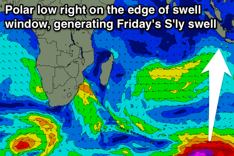
Building mix of S'ly and SW swells from tomorrow
Nias, Mentawai, South Sumatra forecast by Craig Brokensha (issued Sunday 1st may)
Best Days: Every day over the coming at exposed breaks
This coming week and weekend (May 2 - 8)
After a strong kick in S'ly groundswell Wednesday afternoon and Thursday, wave heights have backed off gradually over the past few days, bottoming out this afternoon and tomorrow morning with variable winds.
Into tomorrow afternoon though a mix of new SW groundswell and acute S'ly groundswell are due, the former continuing to build towards a peak Wednesday, while the S'ly swell will be followed by a secondary larger kick Tuesday afternoon.
The S'ly swells were generated last week by a couple of vigorous polar fronts pushing up and into the south west of Western Austalia.
The first pulse should build to an inconsistent 4-5ft across south facing breaks in the Ments later Monday, persisting around a similar size Tuesday, if not for the odd bigger bomb set.
The S'ly swell should then drop away through Wednesday, further Thursday.
Now, coming back to the SW groundswell due to build through tomorrow, further Tuesday and peaking Wednesday, this was generated also later last week by a flurry of strong polar frontal activity under South Africa.
Exposed breaks should build to 3ft+ later Monday, further towards 5ft on the sets Tuesday afternoon ahead of a peak Wednesday to 4-6ft. A slow easing trend is then due from Thursday, down through Friday and Saturday (softened a little by a smaller reinforcing SW swell).
 One final pulse of long-period S'ly groundswell is due later Thursday and Friday morning across the region, generated by a vigorous polar low that's fired up in the Heard Island region and is expected to generating severe-gale to storm-force W/SW winds on the edge of our southern swell window.
This swell won't be as big as the S'ly swells early this week but should still peak Friday morning in the 4ft range.
Coming back to the conditions, and variable winds should continue through until Thursday before weak W/NW winds surface, tending variable again from Sunday week.
Longer term there's still nothing too major on the cards for us beside small amounts of SW groundswell. Check back Tuesday for more on this.
16 day Mentawai forecast graph
16 day Nias forecast graph
16 day South Sumatra forecast graph

