Fun swells for more exposed breaks
Nias, Mentawai, South Sumatra forecast by Craig Brokensha (issued Thu 14th Aug)
Best Days: Every day over the coming period
This Friday onwards (Aug 15 -onwards)
We've seen the swell slowly ease over the last couple of days, but a low point should have been seen this morning ahead of a new S/SW groundswell pulse this afternoon.
This long-range S/SW groundswell is expected to peak tomorrow morning with inconsistent 4-6ft sets in the Ments, with a touch less size around Nias and more consistent sets to 6ft around South Sumatra.
Winds should be favourable and variable across all regions and remain so into Saturday as the swell eases.
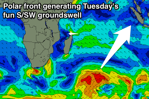
Into Sunday and Tuesday two similar long-range and inconsistent S/SW groundswell pulses are due across the region, generated by a couple of strong but unconsolidated frontal systems pushing north of Heard Island the last couple of days and this morning.
 The first pulse should fill in Sunday and peak in the 4-5ft+ range across the Ments and 5-6ft around South Sumtra, with Tuesday's pulse being a touch stronger to 4-6ft and 5-6ft+ respectively.
Winds should remain generally variable in the Ments but South Sumatra will see weak E/SE to SE trades developing from Saturday and persisting all week.
From Tuesday the swell will slowly drop away leaving small waves into the end of the week. We may see a good new S/SW groundswell next weekend followed by some larger and more powerful activity into the following week, but we'll review this Tuesday.
16 day Mentawai forecast graph
16 day Nias forecast graph
16 day South Sumatra forecast graph

