Indonesia/Maldives forecast Jan 23

Indian Ocean Basin analysis by Craig Brokensha (issued Thursday 23rd January)
This week through next (Jan 24 - 31)
The size is on the slow decline following the large pulse seen on Monday, with the energy due to bottom out on Saturday.
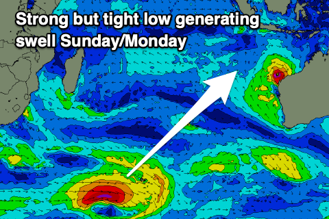
Into Sunday, our inconsistent, long-range SW groundswell is due to start filling in, with it generated by a tight, strong but distant polar low that formed west of the Heard Island region earlier this week.
It’ll be inconsistent but the swell looks strong, with it building through Sunday afternoon, likely peaking later and into Monday morning.
The models are showing a further pulse Monday evening/Tuesday but this isn’t the case with the models incorrectly combining the easing groundswell and background mid-period energy.
Otherwise small levels of mid-period S’ly swell from a fetch of strong S/SE winds off the Western Australian coast is due mid-late next week, mixed in with some slightly better mid-period S/SW energy Friday, generated by a weak frontal progression projecting towards Western Australia early next week.
Longer term the outlook is still slow but we could see a couple of slightly better swell producers for the following week. More on this next Tuesday.
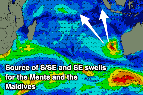
In the Mentawais we should see some S/SE groundswell from Severe Tropical Cyclone Sean following in this afternoon, holding tomorrow and then persisting through the weekend thanks to a persistent fetch of tight, strong to gale-force winds aimed through our swell window as the tropical storm weakens.
Also in the mix on the weekend will be the inconsistent S/SW groundswell, providing better energy Saturday afternoon and Sunday, easing Monday.
----------------------------------------------
Maldives: A new, long-range S/SW groundswell is due to be in the water today, with it backing off slowly through tomorrow, further into the weekend.
The inconsistent groundswell from Severe Tropical Cyclone Sean should arrive out of the SE on the weekend, building Saturday afternoon but peaking Sunday/Monday and then easing slowly for the rest of the week.
The only other source of swell then will be some new S/SE trade-swell for possibly later next week but more so the following weekend, generated by a weak but persistent fetch of E/SE winds to our south during next week.
Check back next week to see how this evolves.
Eastern Indonesia:
Small, inconsistent SW groundswell building Sunday afternoon to 4-5ft across the magnets, holding Monday.
Small levels of background S/SW swell next week, strongest Friday and to 4ft on the magnets.
Variable winds, locally offshore each morning, with afternoon sea breezes.
Uluwatu 16-day Forecast Graph/WAMs
Western Indonesia/Mentawais/South Sumatra:
Small levels of S/SE swell for this afternoon, holding tomorrow through the weekend to 3-4ft on the south magnets. Easing swell next week.
Small, inconsistent SW groundswell for later Saturday, peaking Sunday to 4-5ft, easing Monday.
Light NW winds across southern locations tomorrow, variable into the weekend.
Increasing NW winds across most locations likely late next week..
Mentawai 16-day Forecast Graph/WAMs
Maldives:
Small NE windswell for the coming days and early next week.
Inconsistent S’ly groundswell today to Thursday to 3ft+ on the southern atolls, easing slowly over the coming days..
Small, inconsistent SE groundswell building Saturday, peaking Sunday through Monday to a slow but strong 3-4ft, easing slowly thereafter.
Building S/SE trade-swell next Friday but more so next weekend.
Strong E/NE winds to the north and central locations tomorrow and Saturday, fresh NW to the south tomorrow, weaker on the weekend.
Strengthening E/NE winds across northern and central locations Sunday, more variable to the south, with slightly weaker winds Monday to the north.
Persistent NE winds across northern and central regions next week, more variable to the south.
Comments
Latest notes are live.
Yesterday was fun on NL , headhigh to overhead, light onshore. Today is barely knee high. Mahi-mahi are on the go , frustrating trolling however with so much rubbish in the water .