Indonesia/Maldives forecast Jan 21

Indian Ocean Basin analysis by Craig Brokensha (issued Tuesday 21st January)
This week through next (Jan 22 - 31)
Late last week’s pumping swell was quite prolonged, easing slowly through Friday and Saturday ahead of our new, larger S/SW groundswell into Sunday afternoon/Monday.
This swell peaked through yesterday, though not to the quality of the first swell and has since dropped back across the region.
The easing trend will continue into the end of the week with no real swells of note due across the region.
Background long-period and mid-period swells will stop it going totally flat but we can expect exposed breaks to bottom out in the 3ft range on Saturday.
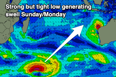
On Sunday afternoon, a small to moderate sized, inconsistent SW groundswell is due to fill in, with the source being a small, tight low that formed west of the Heard Island region yesterday. A great fetch of gale to severe-gales should generate a note-worthy swell with nothing else to otherwise worry about.
Otherwise the Southern Ocean remains void of any major swell generating systems with small, background mid-period energy due for the rest of the week.
Over in the Mentawais, there’s expected to be a small pulse of acute S/SE energy across selected spots Thursday afternoon through Friday, persisting through the weekend.
The initial source will be Severe Tropical Cyclone Sean that’s currently sitting off the Western Australian coast, squeezing a high pressure ridge.
This is aiming a fetch of strong S/SE winds up through our southern swell window with stronger core winds but over a tiny area.
The energy doesn’t look overly significant but with nothing else of real significance in the water it’s worth keeping an eye out for.
----------------------------------------------
Maldives: Easing levels of S’ly groundswell are currently being seen across the region and this will continue ahead of a new, long-range S/SW groundswell for Thursday.

It might be seen later Wednesday but the source was a strong low to the south-west of South Africa last week.
With this, it’ll be very slow but will keep the southern atolls active.
Otherwise Severe Tropical Cyclone Sean should generate some small, inconsistent SE groundswell for the weekend. The swell looks to build Saturday afternoon, hold Sunday/Monday and then slowly ease through next week.
We may see building levels of SE trade-swell later next week as a fetch of E/SE winds sets up south-east of the region early next week. More on this Thursday.
Eastern Indonesia:
Easing S/SW swell over the coming week.
Small, inconsistent SW groundswell building Sunday afternoon to 4-5ft across the magnets, holding Monday.
Small levels of background S/SW swell next week.
Variable winds, locally offshore each morning, with afternoon sea breezes. Winds taking a W/SW-SW tendency into the afternoon’s from the weekend.
Uluwatu 16-day Forecast Graph/WAMs
Western Indonesia/Mentawais/South Sumatra:
Easing S/SW groundswell this week.
Small, inconsistent SW groundswell for later Saturday, peaking Sunday to 4-5ft, easing Monday.
Small levels of S/SE swell for Thursday afternoon, holding Friday through the weekend to 3-4ft on the south magnets. Easing swell next week.
Easing W/NW-NW winds across southern locations tomorrow morning, variable to the north with lingering NW winds into the end of the week across southern locations.
Variable winds from the weekend with increasing NW winds across southern locations next week.
Mentawai 16-day Forecast Graph/WAMs
Maldives:
Easing S’ly groundswell tomorrow, with a reinforcing, inconsistent pulse for Thursday to 3ft+ on the southern atolls.
Slowly easing swell from Friday through the weekend.
Small, inconsistent SE groundswell building Saturday, peaking Sunday through Monday to an inconsistent but strong 3-4ft, easing slowly thereafter.
Building SE trade-swell late next week.
Variable N winds tomorrow, tending NE into Thursday to the north, NW to the south.
Freshening E/NE winds to the north and central locations Friday, weaker NW to the south.
NE winds across northern and central regions Saturday, weaker N/NW to the south, similar Sunday.
Similar winds playing out next week.
Comments
Latest notes are live.