Indonesia/Maldives forecast Jan 2
Indian Ocean Basin analysis by Craig Brokensha (issued Thursday 2nd January)
This week through next (Jan 3 - 10)
A good pulse of mid-period S/SW swell should be filling in across the region today, with it due to ease temporarily into tomorrow morning ahead of a long-period S/SW groundswell later in the day, peaking Saturday.
Both swells performed well in Western Australia and there’s no change to the expected size with Saturday morning revealing the peak before easing into the afternoon, further Sunday and Monday.

A monsoonal surge (mostly to the west) moving through the region will weaken but shift towards the Bali region tomorrow bringing fresher W/NW to W/SW winds, weakening but persisting into the weekend before strengthening a little again early week and then going more NW Tuesday then variable Wednesday.
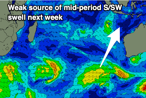
Unfortunately swell sources will dry up with no decent swell due besides some weak mid-period S/SW energy Wednesday.
This doesn’t look to top 4ft across the magnets before fading into the end of the week and next weekend.
----------------------------------------------
Maldives: The Maldives is seeing a mix of easing SE trade-swell and mid-period S’ly swell with the trend continuing out of the SE through the weekend.
The groundswell impacting eastern Indonesia into later tomorrow/Saturday should offer some inconsistent sets across our southern atolls Saturday before fading Sunday.
The possible SE energy from a tropical depression deepening south of Sumatra now looks minimal thanks to the low coming in very weak. A 2ft wave may be seen through next week from Wednesday but that’s about it.
Otherwise local strong NE winds feeding from Sri Lanka will generate some more local NE windswell that’s due to persist from today through the weekend before slowly weakening from Sunday into next week as winds relax.
Southern locations will see strong W winds today and tomorrow, tending more W/NW-NW on the weekend while slowly weakening.
Eastern Indonesia:
Moderate + sized mid-period S/SW swell today, peaking into the afternoon to 4-6ft.
Stronger S/SW groundswell Saturday building Friday afternoon, peaking Saturday morning to 6ft+ across exposed breaks, easing into the afternoon, further Sunday and next week.
Small mid-period S/SW swell next Wednesday to 4ft max across the magnets.
Fresher W/NW to W/SW winds tomorrow, weakening but persisting into the weekend before strengthening a little again early in the week and then going more NW Tuesday, variable from Wednesday.
Uluwatu 16-day Forecast Graph/WAMs
Western Indonesia/Mentawais/South Sumatra:
Small-mod sized S/SW swell today to 4ft across exposed breaks.
Secondary inconsistent S’ly groundswell Saturday to an inconsistent 4-6ft, easing slowly Sunday.
Small mid-period S/SW swell Wednesday to 2-3ft.
Variable winds today with a slight westerly tendency, variable NW tomorrow and Saturday across southern locations, more variable all over from Sunday. Possible freshening N/NW winds later next week.
Mentawai 16-day Forecast Graph/WAMs
Maldives:
Fading SE trade-swell and S’ly swell today.
Small-moderate sized NE windswell building today, holding tomorrow and Saturday, easing slowly from Sunday.
Less consistent but strong S’ly groundswell arriving later Friday, peaking Saturday to 3-4ft across the southern atolls, easing Sunday.
Small SE swell to 2ft from mid-next week.
Strong NE winds across northern locations with W’ly winds across southern locations, easing from Sunday (tending more W/NW-NW across southern locations) and variable next week.


Comments
Latest notes are live.
Thanks Craig , look forward to light winds in a few weeks .
not even 1ft today at Keramas
That’s really surprising amb , shipwrecks was headhigh , crap onshore winds but about 10 guys on it , xmas holiday crowd . That was this morning , tiny now .