Indonesia/Maldives forecast Dec 17

Indian Ocean Basin analysis by Craig Brokensha (issued Tuesday 17th December)
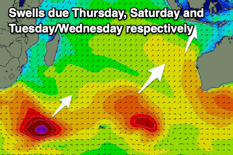
This week through next (Dec 18 - 27)
After bottoming out this morning, we’ve got our large mix of inconsistent SW groundswell and more consistent S/SW energy due over the coming days.
A strong frontal progression that moved across the southern Indian Ocean from south of South Africa initially generated some moderate + sized, inconsistent SW groundswell energy, but it’s the developments south-west of Western Australia over the weekend that will produce the largest surf.
The low stalled and projected various fetches of gale to severe-gale winds through Indonesia’s southern swell window, with the swell coming in large and on forecast for Western Australia yesterday and this morning.
With this we’re not expecting any change in the expected size with a peak likely later tomorrow and into Thursday morning across eastern locations, easing into Friday.
A good, reinforcing SW groundswell is then due into the weekend, produced by a strong trailing frontal progression behind the low linked to tomorrow’s energy. This will be a little less consistent and under the size of the coming days but still strong.
Into next week, moderate + pulses of SW and S/SW swell respectively are due, generated by continued favourable frontal activity through the Southern Ocean. A strong frontal system that’s south-east of South Africa should produce an inconsistent swell for later Tuesday, next Wednesday, while a secondary strong storm firing up south-west of Western Australia may generate a S/SW swell for late week. More on this next update.
Monsoonal westerly winds will kick back in from today again, persisting into Saturday before abating slowly Sunday and into next week.
----------------------------------------------
Maldives: Strong levels of S’ly groundswell should be easing across the islands today with it becoming smaller into tomorrow ahead of a smaller, less consistent swell into Friday.
The next pulse of S’ly energy is due later Saturday but more so Sunday, generated by a strong low that formed under South Africa yesterday and this should produce an inconsistent but small-moderate sized pulse of energy before fading Monday.
Looking to the south-east, and the trade-swell signal is at a low point, but a restrengthening of E/SE-SE winds to the south of Sumatra and west of Western Australia should generate some new energy from the weekend.
A good 3-4ft of swell is due across exposed breaks Saturday/Sunday before easing slowly through next week.
Winds will become an issue through this week though and weekend, reaching strong to gale-force out of the W limiting options severely, easing and tending back to the W/NW-NW next week.
Eastern Indonesia:
Large mix of SW and S/SW swells building tomorrow to 8ft across exposed breaks later, easing from a similar size Thursday.
Mod-large, inconsistent SW groundswell filling in Saturday to 6ft+, easing slowly Sunday.
Moderate sized, inconsistent SW groundswell for Tuesday afternoon, peaking Wednesday to 4-6ft.
Possible stronger S/SW swell later week.
Strengthening W/NW-W/SW winds from today, abating slowly next week.
Uluwatu 16-day Forecast Graph/WAMs
Western Indonesia/Mentawais/South Sumatra:
Large mix of SW and S/SW swells building today, peaking tomorrow to 6-8ft across exposed breaks, easing slowly Thursday.
Moderate + sized S/SW groundswell for Saturday to 6ft, easing Sunday.
Moderate + sized, inconsistent SW groundswell Tuesday to 5-6ft, easing Wednesday.
Building W swell through next week.
Strengthening NW winds tomorrow (lighter to the north), easing a touch later week but persisting into the weekend.
Stronger W/NW-NW winds likely early next week.
Mentawai 16-day Forecast Graph/WAMs
Maldives:
Moderate sized, inconsistent S’ly groundswell easing tomorrow, with a smaller, reinforcing pulse Friday.
New SE trade-swell on Saturday/Sunday to 3-4ft, easing very slowly next week.
Moderate sized S’ly groundswell Sunday to 3-4ft, easing next week.
Strong to gale-force W winds developing over the coming days, persisting through the weekend, easing next week and tending W/NW-NW.
Comments
Latest notes are live.
Whats going on in the Indian Ocean it just keeps giving. If it wasnt for christmas
next week I would shoot back over. Id happy with that forcast in winter.
Swells already building on Lembongan , lacerations is currently bigger than shipwrecks. It won’t like tomorrow’s winds however . Thanks for updates Craig .
Awesome!
Howling onshore and torrential rain this morning on NL , swells pretty big , hope the guys on the east coast are scoring . Look after your ears .
The Dream is still out there