Indonesia/Maldives forecast Dec 3
Indian Ocean Basin analysis by Craig Brokensha (issued Tuesday 3rd December)
This week through next (Dec 4 - 13)
Our strong but inconsistent S/SW groundswell showed into Friday afternoon and peaked Saturday morning with a reinforcing pulse due into later yesterday and this morning.
This secondary swell has a bit more west in it and is a little less consistent but should be providing large sets across exposed breaks before easing into this afternoon.
We then look at our large, reinforcing S/SW groundswell for tomorrow and Thursday morning.
As touched on in last Tuesday’s notes, the source was a strong, slow moving low that developed south-west of Western Australia over the weekend, with fetches of strong to gale-force winds generating a consistent S/SW swell that’s due to fill in tomorrow and peak later.
8ft sets are due across the exposed breaks later tomorrow and early Thursday (6-8ft mostly), easing thereafter and smaller into the weekend.
Apart from a fun, inconsistent mid-period swell for later Sunday and Monday morning, the outlook is slow until Wednesday, when a new, moderate + sized long-period SW groundswell is due to fill in.
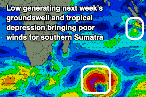
The source will be a strong low firing up to the south-east of Madagascar, north of the Heard Island region, with a fetch of storm-force winds due to generate a strong swell that should peak into Wednesday afternoon/evening, while the secondary, stalling nature of the low should see the size persist mid week.

It looks like we’ll also see our first, proper monsoonal blow develop from this weekend with westerly winds due to persist through next week and beyond, NW in the mornings and W/NW into the afternoons.
Over in the Mentawais, last week’s tropical depression has since weakened, allowing local winds to weaken but we’re due to see another tropical low deepen directly south of the region, bringing strengthening W/NW-NW winds and poor conditions again along with localised levels of swell.
This looks most likely on the weekend, while the southern flank of the low should also generate moderate levels of mid-period S'ly swell early next week ahead of the groundswell from the strong low.
----------------------------------------------
Maldives: The weekend’s SE trade-swell and S’ly groundswell are now on the ease across the region but strong W’ly winds are creating tricky conditions.
Firstly winds are due to slowly ease over the coming week as the tropical activity gets focussed towards Sumatra. A general W/NW-NW flow is due, weak from Friday onwards.
Swell wise, the south-east energy is now smaller and on the decline with it only to start kicking again from the weekend but more so next week as SE winds strengthen on the southern side of the tropical depression forming south of Sumatra.
At this stage only small to moderate levels of swell are due but we’ll review this in the coming updates.
Of great importance is the S’ly groundswell emanating from the low forming south-east of Madagascar. This should produce a moderate sized S’ly groundswell across the southern atolls for Tuesday, peaking into the afternoon and then easing Wednesday.
Eastern Indonesia:
Easing S/SW groundswell today, further tomorrow.
Large S/SW swell building tomorrow, reaching 8ft across exposed breaks (6-8ft mostly) into the PM, easing from 6-8ft on Thursday, smaller into the weekend.
Small-mod sized, mid-period S/SW swell Monday to 3-5ft across exposed breaks.
Moderate + sized SW groundswell building Wednesday, reaching 6ft+ later, easing slowly later week.
Variable, light, locally offshore morning winds ahead of afternoon W/SW-SW sea breezes.
Strengthening W/NW-W/SW winds Sunday, holding from the W/NW Monday/Tuesday. Winds easing from Wednesday and maintaining from the W/NW.
Uluwatu 16-day Forecast Graph/WAMs
Western Indonesia/Mentawais/South Sumatra:
Easing S/SW swell today.
Large S’ly swell arriving later tomorrow, peaking Thursday to 6ft across exposed breaks.
Moderate sized mid-period S’ly swell for Monday/Tuesday to 4-5ft across exposed breaks.
Moderate + sized SW groundswell building Wednesday to 6ft across exposed breaks, easing slowly thereafter.
Building W/NW swell Friday and further into the weekend with strengthening NW winds into the weekend, tending more W-W/SW next week (lighter to the north).
Mentawai 16-day Forecast Graph/WAMs
Maldives:
Small, easing SE trade-swell this week.
Small to moderate sized SE trade-swell building slowly Sunday but more so next week.
Moderate sized, inconsistent S’ly groundswell for next Tuesday to 4ft across the southern atolls.
Easing W/NW-NW winds from tomorrow, lighter from late week.


Comments
Latest notes are live.
Thanks Craig , had some fun 3 -5 ft waves , east coast Bali ( well overhead ) this morning, looking forward to next few days
Very nice.
What's the Maldives usually like mid to late April, Pasta Point area?