Indonesia/Maldives forecast Nov 21
Indian Ocean Basin analysis by Craig Brokensha (issued Thursday 21st November)
This week through next (Nov 20 - 29)
An inconsistent, moderate sized groundswell should be in the water today, but this will back off into tomorrow and Saturday, ahead of our pulse of inconsistent, mid-period S/SW swell Sunday afternoon.
There’s been no change to the expected size and timing of this swell, as with the secondary pulse of energy due into Tuesday afternoon.
The sources weren’t overly great and with this we’re expecting slow surf in the small-moderate size range, likely biggest later Sunday and early Monday, and again later Tuesday.
The size should back off a little Wednesday, while trailing frontal activity north-east of the Heard Island region should produce another reinforcing pulse of S/SW energy Thursday, easing Friday.
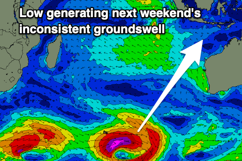
We then look at the stronger polar low that’s due to fire up around the Heard Island region over the coming days, generating a great fetch of storm-force W’ly winds along the polar shelf.

While strong the low is a bit distant and small but we should still see a moderate + sized pulse of long-period S/SW groundswell, building through next Saturday and reaching a peak later in the day and then easing Sunday.
It’ll be inconsistent and to 6ft across the exposed breaks but winds look to be onshore and S/SW-SW into the afternoon when the swell peaks. Following this plenty more moderate sized pulses of swell are due, but more on this Tuesday.
Over in the Mentawais, a deepening tropical depression is bringing localised, low quality W/NW swell and less than ideal conditions to the region and this looks to continue through the weekend and next week as the depression starts to retrograde west but maintain strength.
Winds unfortunately don’t look to back off from the NW until later next week/weekend.
----------------------------------------------

Maldives: S’ly swell should start to ease through today and we’ll then see new levels of moderate sized SE trade-swell taking its place from the weekend and into next week.
This will be thanks to a great fetch of strong E/SE-SE winds feeding into the south of the tropical depression, with it intensifying as the system retrogrades back west towards us on the weekend and next week.
This will produce larger, stronger levels of swell into next weekend and beyond, but we’ll look at this closer next week. Unfortunately local winds will remain an issue and quite strong out of the W/NW-W through the period.
Eastern Indonesia:
Long-range SW groundswell today to an inconsistent 4-5ft across exposed breaks.
Easing surf Friday and Saturday.
Small-moderate sized, mid-period S/SW swell building Sunday afternoon, reaching 3-5ft across exposed breaks, easing Monday with a secondary similar sized pulse for Tuesday afternoon, easing Wednesday.
Reinforcing mid-period S/SW swell Thursday to 4ft+.
Moderate + sized, long-period S/SW groundswell showing later Friday but building Saturday, peaking to 6ft into the afternoon.
Variable, light, locally offshore morning winds ahead of weak, onshore afternoon breezes (south-east over the coming days and south-west to west-southwest next week).
Uluwatu 16-day Forecast Graph/WAMs
Western Indonesia/Mentawais/South Sumatra:
Easing long-range SW groundswell from 4-5ft+ this morning.
Smaller, mid-period S/SW swells for the period.
Building mid-period W-W/NW swell today and further tomorrow, persisting most of next week to 4-5ft or so.
Variable winds today and tomorrow, freshening from the NW later Thursday, and then SW to W/NW on Friday depending on location.
Increasing NW to SW winds tomorrow depending on location, NW Saturday and Sunday with trickier winds to the north. Persistent NW winds next week, weakening later in the week/next weekend.
Mentawai 16-day Forecast Graph/WAMs
Maldives:.
Easing S’ly swell tomorrow from 4ft across the southern atolls (smaller Male).
Moderate levels of SE trade-swell for the weekend and next week to 4ft+ across exposed breaks.
Stronger swell for later in the week/next weekend.
Fresh W/SW-W winds across southern and central locations over the coming days, more variable from Male north.
Strengthening W/NW winds slowly through next week, weaker to the north.


Comments
Latest notes are live.