Indonesia/Maldives forecast Oct 24
Indian Ocean Basin analysis by Craig Brokensha (issued Thursday 24th October)
This week through next (Oct 25 - Nov 1)
Moderate levels of swell are persisting across exposed breaks in eastern Indonesia, with a small mid-period S/SW swell due into later tomorrow, providing a little kick in size Saturday before easing Sunday and further into Monday morning.
Now later Monday but more so Tuesday, a new, inconsistent SW groundswell is due, but the source wasn’t great and quite a distance away from us. The models are incorrectly combining the long-period energy with easing mid-period swells and over-forecasting the size.

With this expect a small increase from Monday but not too much.
A better and stronger pulse of inconsistent SW groundswell is then due to build slowly Wednesday, peaking later if not into Thursday morning.
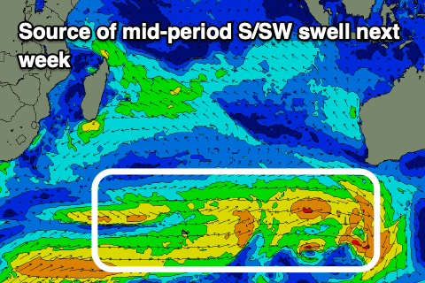
Also in the mix throughout the week will be fun levels of mid-period S/SW swell generated by persistent frontal activity to the south-west of Western Australia. All in all this makes for a fun sized run of surf from Tuesday through Friday next week across exposed breaks. Winds will be funky over the coming days before going weak trade mid-late next week.
Following this the outlook becomes much slower with nothing of note until mid-late the following week. More on this in the next update.
----------------------------------------------
Maldives: Some fun new S/SE trade-swell is in the water today and should continue tomorrow before easing into the weekend. This is thanks to a burst of south-east trades to our south strengthening earlier week, but since weakening.
We’re then due to see some building trade-swell again into early to mid-next week as a broad but weak fetch of SE winds fire up to the south-east of the region over the coming days. It only looks small to moderate in size but otherwise fun.
Across the southern atolls we’ve got good pulses of S’ly groundswell due Sunday and then later Monday/Tuesday from the strong storm activity firing up south-east of South Africa last weekend and earlier this week.
Winds have shifted more S/SW and freshened but we’ll see them shifting back SW-W/SW early next week before easing later week.
Eastern Indonesia:
Small-mod sized, reinforcing mid-period S/SW swell later tomorrow and Saturday morning to 4-5ft across exposed breaks, easing Sunday.
Small, inconsistent SW groundswell for later Monday, peaking Tuesday to the 4ft range across exposed breaks.
Slightly better, inconsistent SW groundswell building slowly Wednesday reaching 4-5ft across exposed breaks later, holding Thursday, easing Friday.
Mid-period S/SW swell also in the mix Tuesday through Friday to 4ft+.
S-S/SW winds over the coming period, variable offshore each morning. Winds tending more W/SW on Sunday with weak E/SE trades mid-late week.
Uluwatu 16-day Forecast Graph/WAMs
Western Indonesia/Mentawais/South Sumatra:
Small-moderate sized S’ly swell for later tomorrow but more so Saturday morning to 4ft across exposed breaks.
Small, inconsistent S/SW groundswell for later Monday, peaking Tuesday to the 4ft+ range across exposed breaks.
Slightly better, inconsistent SW groundswell building Wednesday, reaching 4-5ft across exposed breaks, easing later week.
Variable winds, tending N/NW-NW across the north tomorrow and through the weekend. Winds tending S/SE-SE across southern locations from Tuesday next week.
Mentawai 16-day Forecast Graph/WAMs
Maldives:.
New, moderate sized S/SE trade-swell today and tomorrow to 4ft (smaller Male), easing into the weekend.
Small S’ly groundswell Sunday to 3ft across the southern atolls, with a secondary better pulse for Monday afternoon/Tuesday to 4ft+.
Building SE trade-swell later Monday holding Tuesday to 3ft+, easing slowly Wednesday.
Fresh S/SW winds tomorrow and over the weekend, shifting SW Monday and then W/SW Tuesday, Wednesday, weaker later week.


Comments
Latest notes are live.
Thanks Craig , got the stink SW winds on NL , it would be ok if they would just back off a bit .
In the Ments and today was epic with no wind and glass from dawn. Surfed a magnet and 6-8ft glass on the sets. Weird as thought today was a bit of a low point. Other days also super fun but today the pick.
Good to read that you’re scoring DX3 , such a magic part of indo .
Wow, 6-8ft? Yeah that's way over what's expected. What are you seeing Supa?
@Craig , only head high at best on NL , overhead on ceningan .
Thanks, that's quite a weird one Dx3.
Yeh I should clarify it was about a 60min pulse where the sets were pumping, guess we just timed it well as then it came back to a more consistent 4-5ft. Crowds are light so having an epic time.
Dx - Magnets name ?
Guessing Thunders..
No forecasts this week Craig ?
I think Craig’s on leave.
Yeah he's in Japan. And getting some good waves by the looks of it.
thanks mate
Anyone playing along at home care to have a crack at this friday-tuesday day run of 5-6ft on the model forecast?
How do you think it shapes up in real world size along the Bukit?
When I was down at rote last month and the models were saying 1ft for days & days it was pretty disheartening . One morning woke up to pumping well overhead waves that lasted 4 days. Forecast on 4 different websites didn’t have this swell. The Aussie bloke that ran the place where I was staying said he subscribed for years to www.lookoutthefuckingwindow.com .8th onwards looks fun even with low period, 11th maybe the best , hopefully the forecasted wind pattern holds . Hope ya score wherever you are .
Shouldn’t these winds be flicking to a more westerly flow by now?
It’s normally the month of change , we had westerlies last week on NL that were strong in the morning then back off to nothing by 8.30-9.00 am then later a SSE would kick in after lunch. Last December it was ESE for the majority of the month , guys surfing ulu’s in December with headhigh to overhead waves .
Looks pretty small today Supa
Knee high